
Introduction
India and China share border of 4056 Km in length (as per Ministry of Home Affairs). Compromised by China’s military aggression in 1962, the Line of Actual Control (LAC) in Ladakh’s Sub Sector North (SSN) delineates that part of the Indian territory which China has usurped since 1962. The area is a part of the border dispute in which India, based on historical and traditional legacy, does not accept expansionist border alignments claimed by China.
With a clear intent of militarily expanding across the LAC into all parts of Indian territory claimed by her, China has been engaged in building elaborate transportation and other infrastructure all along the Indo-Tibet border. At the same time, China contests India’s right to develop such infrastructure within her own territories.
China’s Infrastructure Build Up
To provide connectivity to the Southern Tibet region which is rich in natural resources, China decided to construct a road all along the Indo-Tibet border as early as 1951. Construction of China’s National Highway 219 (G219) thus commenced to connect Lhasa in Tibet Autonomous Region (TAR) to Yecheng in the Xinjiang Uyghur Autonomous Region (XUAR) over a distance of 2342 km. The road got completed in 1957. The road passes through the Indian area of Aksai Chin which was surreptitiously occupied by China and as such it triggered the disputes. Initially, it was a gravel track but later paved with asphalt in 2013.
Under the China National Highway Network Planning (2013-2030), the route was expanded both northward and eastward to span China’s entire western and southern border. This new route network measures over 10,000 km, stretching from Kom-Kansas in Xinjiang to Dongxing in Guangxi. China has also taken up construction of approach roads from the main Highway on its side of occupation right up to the LAC to ensure faster mobilisation of troops from the hinterland. No wonder that in most areas their motorable road network exists up to the LAC. A total of 58,000 km of road networks have already been constructed in the TAR; more are under construction.
The People’s Republic of China (PRC) has also improved air connectivity to the region. Air bases of the People’s Liberation Army Air Force (PLAAF) in the Xinjiang and Tibet regionsexist at Hotan, Gar Gunsa, Kashghar, Hopping, Dkonka Dzong, Linzhi and Pangta. The Chinese have upgraded a number of these bases in recent times to include construction of hardened air-pens and shelters, extension of runway lengths and deployment of additional manpower to carry out sustained operations. Reportedly, the Linzhi airbase opposite our North-East is mainly a helicopter base. The Chinese have also built a network of helipads to enhance their operational activities in the border areas.
Rail connectivity to border areas from mainland China is through the Qinghai-Tibet Railway Line connecting Golmud in Qinghai and Lhasa in TAR. It has enhanced the operational capability of the PLA to reach from Golmud to Lhasa in 36 hours. Thus a build-up which was earlier thought to be possible over two seasons, is now possible in just 15 days. The Lhasa- Shigatse Railway Line has been subsequently constructed and it will soon be extended to Dromo near Sikkim - close to Doklam and even Nyingti opposite Arunachal Pradesh. Having already constructed and operationalised a spectacular rail network in Tibet, China is now looking to stretch its railway link through Nepal up to the latter’s border with Bihar.
India’s Infrastructure Build Up
Better connectivity to the border areas and infrastructure build up in remote areas is an important element in ensuring territorial integrity of the nation. It is rightly said that construction of the Darbuk- Shyok- Daulat Beg Oldie (DSDBO) Road has rattled China. One of the reasons for their latest aggression in Eastern Ladakh had been their appreciation that this Road is likely to pose threat to their vital interest of keeping the China Pakistan Economic Corridor (CPEC) safe from interdiction by India. Eastern Ladakh’s Sub Sector North (SSN) lies just to the East of the Siachen Glacier and provides direct access to Aksai Chin from the West. It is therefore speculated that this Road, in conjunction with the Advanced landing Ground (ALG) at Daulat Beg Oldie (DBO), could give India options to interdict G-219 from the SSN.
The current tension at the LAC in SSN can be traced to China’s worry and objections over India’s road construction activities. China is particularly concerned about construction of a road branching from the DSDBO Road towards the Galwan Valley along with a bridge across the Galwan River. The road-bridge is part of a network of feeder roads that India is building to connect DSDBO Road with our LAC positions. This bridge is about 7.5 km from the LAC and the Chinese suspect that it will bring Aksai Chin within India’s reach.

Better infrastructure will definitely reduce the extent of advantage which China has over India due to better infrastructure that it has built over the years on its side of the LAC.
Agencies and Programmes
The Border Roads Organisation (BRO)
The BRO was formed in May 1960 with the mandate to develop infrastructure in remote areas of the North and North-East states of the country. In order to ensure coordination and expeditious execution of projects, a Border Roads Development Board (BRDB) was also formed. The Board exercises financial and other powers of a Department of Government of India and is chaired by the Raksha Rajya Mantri (RRM). Among others, Chief(s) of Army and Air Staff, Engineer-in-Chief, Director General Border Roads (DGBR) and the Financial Advisor (Defence Services) are members of the BRDB. Secretary of the Board exercises the powers of Joint Secretary to the Government of India. Executive head of the BRO is the DGBR who holds the rank of Lieutenant General from the Corps of Engineers, Indian Army. In a bid to boost border connectivity, the BRO has been brought fully under the Ministry of Defence (MoD).
BRO has been keeping pace with the advancements in the domain of technology. With better funding in recent times, it has inducted latest equipment and machinery. BRO has also introduced modern construction techniques, after due trials in order to expedite execution of works. Surfacing with cementation base, use of plastics, geo-textiles etc., various techniques for slope stabilization and construction of modular bridges are some such advancements. Significantly, under the Prime Minister’s ‘Make in India Initiative’, trials have also been carried out successfully on indigenously produced modular bridges. This will revolutionize our bridge laying capability in the forward areas.
Border Area Development Plan (BADP)
Although the BRO was working in the border areas and steadily building the roads and bridges, progress was rather slow since the budgetary crunch began in 1990 and continued till about 2011. Besides, many policy makers rationalised this slow progress as an outcome of a post-1962 defeatist perception whereby Delhi apprehended that such infrastructure would facilitate PLA’s offensive into own areas in the event of another war.
During the 7th Five Year Plan (1985-90), the scheme of BADP was introduced and now it is operational in 111 districts of 16 States and two Union Territories (UT). These are: Arunachal Pradesh, Assam, Bihar, Gujarat, Himachal Pradesh, Jammu&Kashmir (UT), Ladakh (UT), Manipur, Meghalaya, Mizoram, Nagaland, Punjab, Rajasthan, Sikkim, Tripura, Uttar Pradesh, Uttarakhand and West Bengal. The aim of BADP is to facilitate intervention of the Central Governmentin developing border areas. This is done by supplementing the States’ funds to bridge the gaps in socio-economic infrastructure on the one hand and to improving the security environment in border areas on the other. Financial allocation for the year 2020-21 is Rupees 705.055 crore.
India is building roads, including 17 highway stretches in areas near its international borders, that would double up as airstrips. According to the Transport Ministry, the Centre plans to set up a total of 29 airstrips at strategic locations on the National Highways for emergency landings of fighter aircraft. The proposed airstrips have been planned on highways and roads near the international border in the Union Territory (UT)/states of Jammu & Kashmir (J&K), Punjab, Haryana, Rajasthan, Gujarat, Uttarakhand, Manipur and West Bengal - barring three, all are in border areas. The Government has also started construction of an emergency landing airstrip, a 3km long runway, along the newly constructed NH-44 in South Kashmir in Bijbehara area of Anantnag district.
China Study Group (CSG)
In the wake of heightened road and track construction work undertaken by China along India's Northern and Eastern frontiers, the Government constituted the CSG in 1997 to study the matters of Chinese activities and recommenddue responses. At the end of a study on road communication for brisk movement of troops in case of Chinese aggression, the CSG identified 73 roads, named as India-China Border Roads (ICBR), to be developed along the Indo-China border. In 1999, the Cabinet Committee on Security (CCS) approved construction of these roads by the BRO under control of the MoD. The project was to be completed by 2006 but the deadline was extended to 2012 but even that did not change the stagnant situation. In 2018, the Standing Committee on Defence (SCOD), a body for legislative (Parliament) oversight, re-appraised India’s strategic roads connectivity.
India-China Border Roads (ICBR)
This is a Government of India project which aims to develop infrastructure along the Sino-Indian Border by construction of‘strategic roads’. Several entities are responsible for constructing ICBR, including the BRO which handles the bulk of the ICBR construction work, theNational Highway authority of India (NHAI), Central Public Works Department (CPWD), National Projects Construction Corporation (NPCC), National Building Construction Corporation (NBCC), and Public Works Departments of respective states.
The MoDhas submitted a total operational requirement of 852 roads of length 30,118 km to the BRO. Out of this, border roads have been classified under the Long Term Roll-on Works Plan (LTRoWP), that is, 530 roads spanning 22803 km including 73 ICBR in Phase I. The work structure for the ICBR is divided among different agencies. Out of the 73 ICBR, BRO is constructing 61 roads while the remaining are allotted to other departments such as the NBCC, CPWD, NPCC and state PWDs. ICBRs are located in the UTs of J&K and Ladakh, Himachal Pradesh, Uttarakhand, Sikkim and Arunachal Pradesh. Arunachal Pradesh has the most proposed ICBR, numbering 27.
The BRO is responsible for constructing a total of 105 ICBRs, including 73 ICBRs in Phase-1,slated to be completed by December 2020, and another 32 ICBRs in Phase-2. It is thus responsible for total road network of 32,000 km length, out of which 67 percent are assigned to ICBR roads. Out of 73 ICBRs in Phase-1, less than 50 percent had been completed by 2018. Subsequently, with additional funding, the speed of construction has increased. Some of the important projects include the already completed DSDBO Road and the Rohtang Tunnel, named as Atal Tunnel, in Himachal Pradesh on Manali-Leh Axis. In the North-East there are the under construction Se La Tunnel and a tunnel being constructed by the Indian Railways under the Brahmaputra River.
As compared to FY 2018-19, the Border Roads has executed 30 percent more works in the financial year (FY) 2019-20. The Raksha Mantri, during a recent review, has directed that the 255 km road along the LAC (DSDBO Road) in the northern Himalayan region of Ladakh be completed on priority. The ongoing construction here is almost complete except for the last 45 km. It is believed that the Raksha Mantri had ordered that this be completed by October 2020, but given the situation there, that seems to have been delayed.
Tunnels to Provide All Weather Connectivity
One of the greatest challenge for the Armed Forces is to maintain an all-weather connectivity to Ladakh region. Ladakh range is the one which needs to be tunnelled to ensure that kind of connectivity. A total of 19 tunnels are planned to come up along India’s frontier with China and Pakistan. Out of these 15 will be in J&K and Ladakh. These also include those tunnels which have already got completed as well as the proposed ones. In addition to these there are plans to construct four tunnels to come up on the Akhnoor-Poonch Road in J&K.
New tunnels that are being planned for India’s Western Front are at the Sadhna Pass connecting Kupwara to rest of Kashmir and Pharkiyan Gulli in Kupwara of J&K. In the East a global Tender has already been issued for a 15 km long tunnel under the Brahmaputa River in Assam. Excavation work has commenced for a tunnel for Sela Pass at an altitude of 4172 meters in Arunachal Pradesh. Work on another tunnel in Nepchiphu in Arunachal Pradesh is soon to commence. This tunnel will shorten the travel time to Tawang.
Coming to Ladakh, it will be few years before India can boast of an all-weather connectivity to the UT of Ladakh. Undeterred of the humungous challenge, the Government is continuing with its efforts to improve connectivity to Ladakh along both the axes, namely, the Manali Axis and the Zoji La Axis; it is also looking for a third one. Details are as follows:-
Rohtang Tunnel on Manali-Upshi Axis.

This Axis is already complete and has been inaugurated on 03 October 2020. The Rohtang Tunnel helps connectivity to Lahul and Spiti Valley, but is not enough to ensure all-weather connectivity up to Ladakh, as there are four more high passes on this route– namely, Baralacha La, Nakee La, Lachung La and Tanglang La – where tunnels are needed to make this Axis all-weather. Although the feasibility study for a 13.7 km tunnel at Baralacha La has been completed but the project will take a long time to fructify.
a. Srinagar-Leh Axis. This Axis faces excessive snow load during the winter months. By best efforts it may be possible to reduce the closer period but it is difficult to keep it open all through the winters.

c. Zoji La Tunnel. This will be a 14.5 km tunnel. The tendering process is complete, contract has been awarded. It is being executed under the arrangements of National Highway and Infrastructural Development Corporation (NHIDCL) under the Engineering Procurement and Construction (EPC) model wherein the entire funding is from the Government. It is likely that the cost of construction is going to be Rs. 4509 Crores. Work has finally commenced with effect from 15 October 2020. Although the Minister of Surface transport Shri Gadkari hoped at the time of first ceremonial blast that it will be ready before 2024 but scheduled time for completion is 72 months. Thus notwithstanding tall claims this Axis is likely to be ready not before2027.
d. Z Morh Tunnel. This tunnel is the first step toward ensuring all-weather connectivity between Srinagar and Kargil. The tunnel gets its name from the Z shape of the road that it will cover between Sonmarg and Gagangir. It is planned to be a 6.5 km long road tunnel near Gagangir in Ganderbal district of the UT of J&K. The tunnel would avoid the regions of snowfall and avalanches which is the key factor. Work on this stalled project recommenced during June 2020. The completion time is 42 months and it is likely to be completed by December 2023. Completion of Zoji La tunnel will substantially depend on timely completion of the Z Morh Tunnel.
e. A Third Axis to Ladakh.
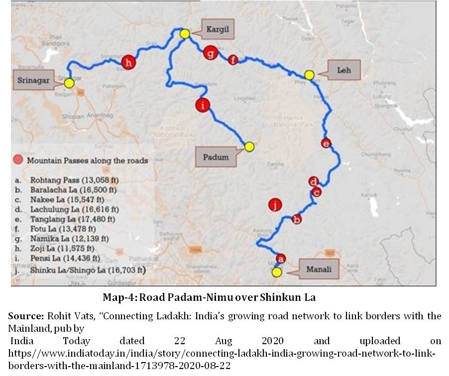
Recently, there was a news item (TOI 28 August 2020) that announced acceptance of a tunnel at Shinkun La on Darcha-Padam-Nimu Road. This project, when completed, will provide a new all-weather axis to Ladakh and could obviate the need to go for the above mentioned four more tunnels on the Manali-Upshi Axis. Operationally also this road will provide a greater strategic advantage besides ushering in development in Zanskar Valley. The NHIDCL, a wholly owned company of the Ministry of Highways, is to prepare, within eight months, a feasibility report for construction of a 12.7 km tunnel under Shinkun La. This Axis will substantially cut the travel time from Pathankot to Leh.
New Roads
In July 2020, underlining a resolve to upgrade roads in the region despite objections from China, the Government had reviewed progress on construction of more than 30 roads along the LAC. Besides Ladakh, projects in Arunachal Pradesh, Sikkim and Uttarakhand were also reviewed during the meeting. According to news reports, the Government has speeded up the process of infrastructure construction and reviewed the money spent since 2014.
Hopefully, the projects being executed will go through as planned for India to make up for the lost time in border area development plans in this part of the country. It needs to be noted that these projects are necessary for defence and India cannot afford any further delay on these. After years of neglect, the Government has finally decided to address the matter of improving connectivity by early completion of 66 key roads along the Chinese border by 2022.
Rail Connectivity to Ladakh
In 2010, 28 strategic railway lines in areas bordering China, Pakistan and Nepal were identified. Not one of these have progressed till date. After a series of interactions with the railway officials, the Defence Ministry reappraised the proposal in November 2010. It has now prioritised 14 of the 28 lines for construction. In December 2012, Shri AK Antony confirmed the same in the Lok Sabha when he described these 14 lines as being strategically important for national security. Preliminary survey for 10 of these was completed, but work did not begin in spite of the fact that these rail lines were declared national projects. The Railway Ministry did not wish to fund these projects as these were not commercially viable.
The MoD then asked the Finance Ministry for additional funds but the Planning Commission ruled that these were not the priority. No decision could thereafter be taken, and the Rail, Finance and Defence Ministries could not agree upon allocation of funds even for the Final Location Survey (FLS).

There was little further progress and the matter went to the National Security Council, which in March 2014, identified four out of these 14 lines for “prioritised construction.” It was informed to the Lok Sabha that four lines had been approved and these were: Missamari-Tenga-Tawang (378 km), Bilaspur-Manali-Leh (498 km), Pasighat-Tezu-Rupai (227 km) and North Lakhimpur-Bame-Silapathar (249km). CCS approval was accorded in 2015 and the MoD was asked to transfer Rs 344.84 crore to the Railways for FLS of these lines. By 2019, the Railways have completed FLS of three among the strategic lines along the country’s border with China.
Besides high costs and lack of funds, tough terrain also poses a challenge for construction of these lines. Experts say India does not have any experience of building rail tracks at high altitude and in tough terrain of the Himalayas. But strategic imperatives dictate that India will have to overcome the technological challenge, whether indigenously or by foreign collaboration.
Bridges
The BRO has been tasked to build a total of 102 bridges this year in Border areas. So far a total of 54 bridges have already been completed and out of these, during the first week of the October, a total of 44 bridges were inaugurated by the Raksha Mantri. Out of these 30 bridges are Class -70 and are enroute to the LAC. Purpose of these bridges is to ensure quick induction of heaviest tanks in the Indian Army’s inventory.
Air Fields/ Advance Landing Grounds (ALG)
According to official statements, there are eight ALGs in Arunachal which have been made operational. These are: Vijaynagar which is close to both Chines as well as Myanmar border, Pasighat, Mechuka, Walong, Tuting, Ziro, Along and Tawang. These are good enough for C-130 J Super Hercules to land. In Sikkim an ALG at Pakyong, 60 km from Indo-Tibet border, has been made functional. Besides, there are a number of Air Forces Bases for fighter and helicopter operations, important ones being at Tejpur, Chabua, Hashimara and Jorhat.
In Ladakh, the ALG at DBO is operational. In addition, plans are afoot to develop the ALG at Nyoma and extend the Kargil Air Field to enable fighter operations. In fact, an air base is planned at Nyoma which would be used even for Fighter operations. The ALG at Fukche has been validated for use by small aircrafts but it is quite close to the LAC. Development of ALG at Chushul has been shelved but it can be operationalised when required. Leh and Thoise airfields are suitable for transport as well as fighter aircrafts. There are large numbers of Helipads in Ladakh but many more are need to come up as in days ahead the Indian Air Force will need to operate drones, attack helicopters and large transport helicopters in the area. Areas for ALGs are also being identified in Uttarakhand.
It needs to be noted that in days to come, more ALGs and helipads to provide air support, casualty evacuation, surveillance and logistic supportwill have to come up all along the Indo-Tibet border.
Conclusion
India has started infrastructure build up in border areas but she is still far behind in this sphere as compared to China. It needs to be appreciated that infrastructure development directly contributes to defence as well as development. India will have to compress the time frame to complete the planned tunnels to provide all weather connectivity; the Prime Minister, at the time of dedicating the Atal Tunnel to the nation, exhorted all concerned to ensure ‘All Weather Connectivity’ to Ladakh at the earliest.
More ALGs and helipads will have to be built because future operations will substantially depend on air operations. Construction of railway lines will have to be taken up more seriously because that will give a quantum leapto seamless integration of the area with rest of the country.
There are fourmore areas which have not been discussed in this paper, but need immediate attention. One of these is better communication and bandwidth for better utilisation of cyber space and surveillance. Secondly, the present capacity of satellite imaging every 20 plus days needs to be reduced to, say, four to five days. Probably a dedicated geo-synchronous satellite may be required to be launched for this purpose. Thirdly, there is a need to deploy improved boats for operations in the Pangong Tso. Fourthly, winters are quite harsh in Ladakh and therefore building of better troops’ habitat will be necessary.
Finally, it needs to be appreciated that China is getting rattled only because of India attempting to catch up with her in infrastructure build up. Therefore, in the wake of current stand-off, the new normal would be quite different from what was in past. India needs to be prepared for a more active and alive LAC. The need is to build-up own infrastructure in a time bound manner. To do so, customised sets of financial and administrative rules and checks and balances will have to be introduced.
(The paper is the author’s individual scholastic articulation. The author certifies that the article/paper is original in content, unpublished and it has not been submitted for publication/web upload elsewhere, and that the facts and figures quoted are duly referenced, as needed, and are believed to be correct). (The paper does not necessarily represent the organisational stance... More >>
Image Source: https://www.deccanherald.com/sites/dh/files/article_images/file7b53x70nrsn1huh8a42l.jpg

-

Israel's security policy has been influenced by a deep sense of r
-

Introduction In recent months, the town of Chaman in Baloch
-

The J&K Assembly elections have seen hectic round of campaigning
-

Any projection of the trajectory of India’s role in the world i
-

Introduction Kazakhstan hosted the Fifth World Nomad Games (WN
-

On 9th September, India and the Gulf Cooperation Council (GCC) he
-

The Sultanate of Brunei is among the smallest countries of ASEAN
-

If Donald Trump wins in the 2025 elections, if personnel appointm
Post new comment