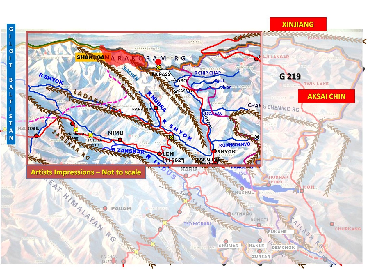
Indeed, the Soltoro Ridge with the Shyok River to its West, the Siachen Glacier and the Nubra Valley and the Saser Muztagh with the Shyok River to its East, is a great geostrategic obstruct to any collusive designs of Pakistan and China. With the Shaksgam Valley in the Trans-Karakoram Tract handed to the Chinese, Gilgit-Baltistan and the Aksai Chin (territories that rightly belongs to India) and Tibet to the East, the region is an immensely important geo-strategic arena. The recent transgressions in the Galwan and Cheng Chenmo Valleys of Eastern Ladakh, the region is in focus with various analysts opining that further Chinese threat to the Siachen Glacier, in an effort to marry up with Gilgit-Baltistan. It is imperative, hence, to examine the pieces of the adversarial puzzle, to ascertain if they tend to make a whole.
A short description will be necessary. Karakoram (KK) Range running East to West has with four major passes– the Karakoram Pass (the Pass of Black Gravel, 18176 feet), Col Italia (that leads to Rimo Muztagh and the Rimo Glacier), Turkestan La (at the head of the Siachen Glacier) and Indira Col (the northernmost pass on the Saltoro, named after Goddess Laxmi). Trans-Karakoram Tract has four large glaciers that drain into the Shaksgam River, which flows due west and finally joins the Yarkhand River. From the KK Ridge, two sub-ranges or offshoots are of major relevance. The first is the Saser Muztagh emanating west of KK Pass, and moving in South Easterly direction. The Rimo Muztagh with Rimo Group of peaks and Rimo Glaciers, emanating from the KK Ridge feed the Shyok River which runs parallel to the Saser Muztagh. West of Saser Muztagh is the famous Siachen Glacier fed by a series of glaciers like the Teram Shehr. The Siachen Glacier develops into the Nubra River, which is a tributary of Shyok. The Second sub-ridge from KK Ridge is the Saltoro, West of the Siachen Glacier/ Nubra River, on which the Indian Army units are deployed. The Shyok and Nubra Valleys are approached over the Ladakh Range via Chang La and Khardung La passes.
Chinese in Gilgit-Baltistan
West of Saltoro Range is Gilgit-Baltistan, which is a part of Jammu and Kashmir, illegally occupied by Pakistan after Partition in 1947. According to Article 1 of the Constitution of Pakistan which defines Pakistan’s territory, areas of Gilgit-Baltistan and Azad Kashmir are not constitutionally parts of Pakistan. Article 257 further stated that these areas formed part of the princely State of Jammu and Kashmir. On 30 April, Pakistan’s Supreme Court’s decision allowed the federal government’s application to set up a caretaker government and conduct provincial assembly elections in Gilgit-Baltistan (GB). India on 03 Dec 2018 voiced strong opposition to Pakistan's reported move to declare Gilgit (Pakistan) as that country's fifth province, and hold elections.
In Gilgit-Baltistan, Ghanche (the word Gangchay in Balti means “glacier”) District, west of the Soltoro Ridge, is the easternmost district of Gilgit–Baltistan and is largely inhabited by Balti speaking Noorbakshi Muslims. Gilgit-Baltistan is endowed with enormous water and mineral resources, Pakistan, in collusion with China, is set to make it one of the world’s largest mining pits. A mass protest took place in the Ghanche district of Pakistan occupied Kashmir (PoK) against the Islamabad`s decision of leasing the pasture land to China for mining. It has been stated that 300 mining leases were awarded to Chinese mining companies in Ghanche District for the much-valued mineral deposits of uranium, gold, copper, marble and precious stones. In the entire Gilgit-Baltistan, reckless mining by greedy Chinese firms are threatening the eco-system in the region.
The Chinese have literally taken over the Gilgit-Baltistan (GB) on lease with over 2000 licences granted by Islamabad to different Chinese companies to mine uranium and other precious minerals and metals used in hi-tech sectors like space. The impact of such massive exploitation of natural resources on the local community and environment would be immeasurable. The region is already under severe stress due to dramatic climate change sweeping the mountainous areas.1 The Pakistan government has leased land in Gilgit-Baltistan to China for 30 years to work on a few projects whose security the People’s Liberation Army (PLA) of China has taken charge of. Some of those are hydro-electricity works, railway projects, tunnels for the railways and roads.2
In May 2019, Pakistan’s Board of Investments (BoI) approved the fast-track development of nine SEZs, including Moqpondass, which is about 40 km from the city of Gilgit towards Skardu. Construction began immediately after the signing of the agreement. Although the Pakistani government’s CPEC website says the area allotted is 250 acres, satellite imagery shows that the Chinese are utilising an area of more than 750 acres. The area occupied by the construction company consists of a storage area, a cement concrete production and mixer plant, and two crusher plants.3 China’s state-run China Power and Pakistan army’s commercial body Frontiers Works Organisation signed an accord to construct the Dam ($5.85 billion) last Wednesday. Diamer Bhasha Dam, probably the world’s highest concretised dam, will stand at a height of 272m with the capacity to hold 8 million acre feet of water. It plans to generate 4,500 mw of power.
The Trans Karakoram Tract
In the strategic Shaksgam Valley, construction activity is evident with China building a 36-km long road and military posts.4 Historically graziers from Hunza had been utilising pasturelands in the Shaksgam Valley. It is likely that eventually, a road alternative to the Karakoram Highway, would be constructed, through the Shaksgam Valley. This will connect NH G219 directly with the Skardu-Gilgit road, thereby bypassing the long-loop from Khunjerab Pass, along NH G319 to Kashgar-Urumuqi.
The feeder road built eastward through the Shaksgam, Raskam and Shimshal Valleys link Gilgit with Hotan, which is situated at the cross- section of Tibet-Xinjiang Highway and the Hotan-Golmud Highway, which links Xinjiang to Qinghai province. Likewise, the feeder road stretching along the southern rim of Xinjiang connects Gilgit with Aksai-Chin and reduces the distance between both regions by more than 800 miles.5
The Over-riding Importance of Aksai Chin
Much is written and known about Aksai Chin. There are plains, plateaus, rivers and the KK/ Lakhtang Range which moves in a North-South direction in Aksai Chin. From the area's lowest point on the Karakash River at about 14,000 feet (4,300 m) to the glaciated peaks up to 22,500 feet (6,900 m) above sea level, this is an extremely inhospitable, desolate and largely uninhabited area. Though Karakash River flows generally northwards towards Kun Lun Range/ Hotan, three major Rivers move from Aksai Chin to finally merge into Shyok in Sub Sector North – the Chip Chap, the Galwan and the Cheng Chenmo.
The NH G219 from Hotan, Xinjiang, enters Tibet over the Kun Lun Range at the Tserang Daban, a 16700 feet high pass and moves through Aksai Chin towards Rutog. The G219 is approximately 150km from Daulat Beg Oldie (DBO), and has a number of axials and laterals in the Aksai Chin. Though movement for vehicles can be feasible in plains and plateaus, due to defiles, high/ low passes and undulating region larger move will be restricted to roads and tracks.
Prognosticating Geo-Strategic Relevance
It is a truism that the Chinese are located on all three directions of Eastern Ladakh-Siachen area. In Gilgit-Baltistan there are obviously geo-political and economic/ pecuniary interests in exploitation of the riches of the area, and to make CPEC a successful venture. There will be some presence of PLA/ other uniformed forces, though it cannot be quantified due to lack of information. In Trans-Karakoram Tract, which has larger glaciated areas, infrastructural development and creation of alternative axes may be relevant. In Aksai Chin, however, the NH G219 is of an over-riding importance, and maximum areas that can provide depth to it, would be important to China.
For the Indian Army, the areas of Saltoro Range, the Siachen Glacier, the Ladakh Range and the icy heights of areas of Batalik-Kargil-Drass, across the Actual Ground Position Line (AGPL) and LOC are sacrosanct, and are stoically defended. Even the Siachen Glacier has well settled down to a systemic. For offensive-defence, and for domination of two lines, the current force posture is credible; there may be requirements of additional construction or upgradation of road-infrastructure, which must be an on-going proposition. As is always so, there would always be side-stepping of forces to a plan. The Eastern Ladakh is another matter. Having procrastinated for over half a century, the infrastructural development and creation of complete eco-system in the last decade has been significant. Hence, the strategic and operational plans for the sensitive LAC are underway, the continuing skirmishes notwithstanding.
Contextually, hence, it is argued that to prognosticate a geo-strategic collusion between the two adversaries in this region, which can turn the tables for the Indian Armed Forces, would be to allow imagination run riot. The severe lay of the land, the harsh vagaries of climate and the strength of the Armed Forces in executing combat in super high altitude areas, precludes a generalisation of geo-strategic linkages. It is only uninspired envisioning that states of prosecution of threat from one adversary, to manifest into marrying up with the other! This argument is not to operationally compartmentalise and segregate the two, but to challenge the imaginative aggregation being undertaken in some print and largely in audio-visual medium. Suffice it say that in Gilgit-Baltistan, with the incipient internal turmoil, and despite the presence of Chinese in varied forms, our ascendant position must be retained.
With the increasing LAC pressures and skirmishes, and this becoming the new normal, there may be need to envisage both modernity and imagination in planning. Four pathways at this juncture may be in order:
- There is an optimal need to create real-time ‘eyes and ears’, a modern Intelligence, Surveillance and Reconnaissance (ISR) system - from space to ground, with secure networking, communication and data-linkages. This cannot be hinged on the altar of financial and budgetary controls, or to long-drawn, open-ended developmental processes of the DRDO/ Defence PSUs. Expertise of the kind envisaged may well be available within the nation largely.
- A re-appraisal of the force-level mandatory needs be done. At every skirmish, the rush of additional forces and capabilities from elsewhere is detrimental to long-term planning. The over-burdened and largely under-utilised capabilities on the Western Front may be re-allocated, without being detrimental.
- Internal capability management within Ladakh and also in Jammu and Kashmir can also be considered, from comparatively dormant areas. In this context, the strong potency of the ‘sons of the soil’ should not be allowed to be dissipated mundanely. Also the Siachen-loop turnover also mandates an imaginative planning, to foreclose a transient outlook towards Eastern Ladakh – area under focus.
- And, lastly, there is but no alternative to modernity of capability, in imbibing electronic and cyber warfare, Precision Guided Munitions (PGMs), Space, and the like. These are no more force multipliers, but independent realms of warfare.
In sum, the linkages being established between Gilgit-Baltistan and Xinjiang (Kashgar-Hotan) and Tibet (Rudok and onwards) would remain dependent on peripheral roads like the G219, or offshoots through Trans Karakoram Tracts. Eastern Ladakh and the Siachen-Soltoro are and will remain a strong obstruct to any collusive adversarial designs in perpetuity. Predicting geo-strategic relevance of skirmishes at DBO, Galwan or Cheng-Chenmo, with larger designs towards Siachen and onwards towards Gilgit-Baltistan, will remain in fertile imagination, only.
End Notes
- Rifan Ahmed Khan, GILGIT BALTISTAN: Protest brewing over mining lease for Chinese firm, Asian Lite News. 22 July 2019 accessed at https://asianlite.com/news/asia-diaspora-news/gilgit-baltistan-protest-brewing-over-mining-lease-for-chinese-firms
- Amir Karim Tantray, Pakistan govt leases land in Gilgit to China, Hindustan Times, Mar 24, 2012
- VINAYAK BHATT, Pakistan & China are building an SEZ in PoK’s Gilgit-Baltistan, satellite images show, The Print, 27 August, 2019, accessed at https://theprint.in/world/pakistan-china-are-building-an-sez-in-poks-gilgit-baltistan-satellite-images-show/282413/
- VINAYAK BHAT, Fresh provocation: China’s building a 36-km long road in strategic J&K valley near Siachen, The Print, 15 January, 2018, accessed at https://theprint.in/defence/china-building-a-36-km-long-road-valley-siachen/28812/
- Senge H. Sering, EXPANSION OF THE KARAKORAM CORRIDOR: IMPLICATIONS AND PROSPECTS, IDSA Occasional Paper No. 27, Lancer Books, New Delhi, Sep 2012
(The paper is the author’s individual scholastic articulation. The author certifies that the article/paper is original in content, unpublished and it has not been submitted for publication/web upload elsewhere, and that the facts and figures quoted are duly referenced, as needed, and are believed to be correct). (The paper does not necessarily represent the organisational stance... More >>

-

Introduction The northeast region of India has been inflicted
-

Indian foreign policy under the Modi government has been characte
-

The general elections for the National Majlis (Parliament) of Mal
-

India possibly can boast of having one of the largest (nearly 35
-

Following the visit of an Indian delegation to Afghanistan in Mar
-

The plenary sessions of the Chinese People’s Political Consulta
-

Background Chief of Army Staff (COAS) of the Indian Army, Gene
-

Premise This work attempts to analyse the following premise:-
This article with map gives a clear perspective of the Geo- strategic analysis of the conflict region. Very educative and easily understood with orentation.
Post new comment