Introduction
Maritime Domain Awareness (MDA) signifies a need for situational awareness at sea, which necessitates being cognisant of the position and intentions of all maritime actors in all dimensions - on, over and under the seas. [1] MDA is increasingly becoming a pre-requisite for safe and efficient conduct of maritime activity, which itself is a major engine for global economic growth. Knowledge, not just of the natural vagaries of the seas, but also the likely challenges on account of human activity, has become an imperative for ensuring the maritime security of this activity.
The maritime domain is complex, both in terms of its expanse and the actors that utilise this space. The United Nations Convention on the Law of the Sea (UNCLOS) classifies the maritime domain based on the proximity to coastal states. While the expanse of the seas till 200 nautical miles from a country’s coastline lies within the jurisdiction of coastal states (with variations in jurisdiction in territorial waters, the contiguous zone and the exclusive economic zone), this still leaves a huge expanse of the maritime domain, the high seas, largely ungoverned and not necessarily monitored. Even large areas under the jurisdiction of coastal states remain unmonitored, either due to lack of capacity of the coastal state or due to geographical limitations. The expanse of the ocean is such that even coastal states with capable maritime forces may be hard put to ensure complete monitoring of their respective areas of maritime jurisdiction. Unlike land and its adjacent airspace, where fixed monitoring/ surveillance systems can ensure near complete situational awareness, the maritime domain does not lend itself to such transparency because of the inability to site such systems over water.
Rising utilisation of the domain has also increased the number of actors, apart from coastal states, to include other stakeholders and entities. While commercial shipping, military vessels and fishing vessels have traditionally frequented the maritime domain, newer users such as leisure craft, unmanned vessels, offshore installations, oceanic research equipment, offshore wind, solar and geothermal energy farms, underwater cables, underwater pipelines and the like have further increased this traffic. The age-old challenges of the maritime domain such as piracy, robbery, trafficking of humans, contraband, arms and drugs continue to permeate the domain. Coupled with modern technologies of communication and deception, these challenges have assumed dangerous proportions.
Ensuring maritime security over the entire maritime domain with such a complex array of actors and varied interests requires situational awareness of a very high order. While situational awareness of the entire maritime domain may not be possible and may also not be required, MDA of areas of interest is absolutely necessary. The Indo-Pacific region is one such area which has become the focus of the world in recent years, especially due to due to the rise of China.
The Indo-Pacific
The Indo-Pacific is home to more than half of the world’s people and nearly two-thirds of the world’s economy. Notwithstanding the geographic contiguity of the region, economic diversity amongst its littorals is stark, with countries like Singapore at one end of the spectrum and Somalia on the other. The Persian Gulf produces nearly one third of the world's oil and holds over half of the world's crude oil reserves, as well as a significant portion of the world's natural gas reserves. The region also produces some of the world’s most critical minerals. Chile is the largest copper producer (28 percent) and the second-largest lithium producer (23 percent), while Australia is the principal producer of lithium products (52 percent). Indonesia is the largest nickel producer, accounting for 31 percent of the world’s nickel mining. [2]Countries of the region like China, India, South Korea and South East Asia account for more than 50 percent of the world’s fisheries production.[3] About 60 percent of the world’s maritime trade goes through the region, which also has nine out of the world’s top ten ports.[4] The Indo-Pacific is also no exception to the growing network of undersea cables which are estimated to carry over 95 per cent of international data and communications traffic. Undersea pipelines, such as those in the Persian Gulf, are also growing in number and will be a significant factor in the future.
Not surprisingly, the Indo-Pacific has thus become the global centre of interest in the recent past with a number of countries publicly articulating their approaches and strategy towards the region. While there appears to be a common understanding of the geographical expanse of the region, revolving around the Indian and Pacific Oceans and their littorals, approaches differ. The US clearly identifies the challenge from China as the reason for the “intensifying American focus”.[5] On the other hand, Europe looks at the Indo-Pacific’s “growing economic, demographic, and political weight”[6] for enhancing its engagement with the region. Resident states like Japan look at the Indo-Pacific as a key for ensuring “stability and prosperity of the international community”.[7] India envisages a free, open, inclusive, peaceful, and prosperous Indo-Pacific region, built on a rules-based international order, sustainable and transparent infrastructure investment, freedom of navigation and over-flight, unimpeded lawful commerce, mutual respect for sovereignty, peaceful resolution of disputes, as well as equality of all nations.[8] China does not appear to subscribe to the notion of the Indo-Pacific and prefers the term ‘Asia-Pacific’ even as it opposes the US’ Indo-Pacific strategy. Nevertheless, it has supported the ASEAN ‘Outlook on the Indo-Pacific’. ASEAN lies at the geographical centre of the Indo-Pacific region and consequently has found mention in all the approaches and strategies articulated by various countries, with most underlining the centrality of the ASEAN and ASEAN-led organisations to the Indo-Pacific.
The Pacific Rim, namely the Pacific Island countries (PIC), and the Indian Ocean rim, i.e. the East African coast and the Persian Gulf, are also becoming increasingly important to the construct of the Indo-Pacific. Africa is developing into an arena of geopolitical competition as a growing market and a source of critical minerals, especially between the US and China. On the other hand, perceptions of US withdrawal have provided the impetus for Chinese activity in West Asia, even as China seeks to consolidate its sources of energy, in this region, for its continued economic progress. While the Indian Ocean has been relatively stable, maritime regions to the East of the Malacca Straits, namely the South China Sea, the Taiwan Strait and the East China Sea, have witnessed incessant frictions between a large number of actors, both state and non-state. In such a milieu, comprehensive awareness of the maritime domain has become a critical factor for ensuring maritime security.
Challenges to MDA in the Indo-Pacific
The diversity of the Indo-Pacific region – economic, demographic, military or developmental – has manifested in the maritime domain in the form of a number of challenges, such as maritime disputes, piracy, Illegal Unreported and Unregulated (IUU) fishing, drugs, arms and people trafficking, and the like. Economic progress has also led to expanding military presence, increased shipping traffic, port development, increased fishing activity, etc., making the Indo-Pacific a very dense and complex maritime environment.
Expanding Navies. According to Stockholm International Peace Research Institute (SIPRI), Asia, Oceania and the Middle East have accounted for more than 70 percent of arms imports over the past ten years.[9] The maritime domain has seen a rise in the induction of ships, submarines and other vessels in the navies of the coastal states of the region. This has caused concern in regions like the South and East China Seas, where such profusion of military platforms has added to existing tensions on account of various maritime disputes.
International Military Presence. The renewed global focus on the region has led to increased extra-regional naval presence, with many countries with interests in the Indo-Pacific deploying forces to the region, such as major recent deployments by the British, German and Dutch navies. As such, the French and United States navies maintain a regular presence due to their territorial and other interests in the region. China’s People’s Liberation Army (Navy) (PLAN), has also extended its footprint to the Indian Ocean since 2008. Anti-piracy deployments of various European and other navies also continue in the north-western part of the Indian Ocean Region (IOR). Consequently, on an average, maritime forces from over 60 countries, including 4-6 Chinese warships, are present in the IOR at any given time of the year.[10]
High Density of Maritime Traffic. The map at Fig 1 clearly shows the high density of traffic in the Indo-Pacific region. While much of this shipping traffic follows established International Sea Lanes (ISL), many vessels follow their own route which makes tracking them difficult. Existent regulations promulgated by the International Maritime Organisation (IMO) mandate all ships above 300 gross tonnes to carry Automatic Identification Systems (AIS).[11] However, many ships turn off the AIS for a variety of reasons and go ‘dark’, which complicates the maritime traffic map and has implications on security and safety at sea.
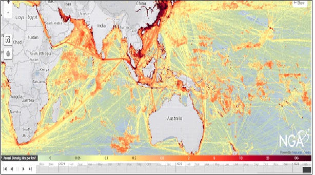
Figure 1: Map of Vessel Density[12]
Fishing. The map at Figure 2 depicts fishing traffic density over the past decade wherein the bright blue and yellow shaded areas depict areas of high density. The Indo-Pacific, especially the eastern part, has a relatively high density of fishing, as compared to the IOR. The South and East China Seas also has a number of ongoing maritime disputes. China also operates a maritime militia, which primarily comprises fishing vessels but also undertakes quasi-military activities including intelligence gathering, maritime rights enforcement, etc. IUU fishing is also highly prevalent with countries like China, South Korea, Taiwan, Thailand, Seychelles and Vietnam figuring in the top ten worst performing countries in the IUU Index.[13] Additionally, most fishing vessels, including those off the Indian coast, do not carry any identification equipment, which creates complexities in identification and tracking of activities of fishing vessels.
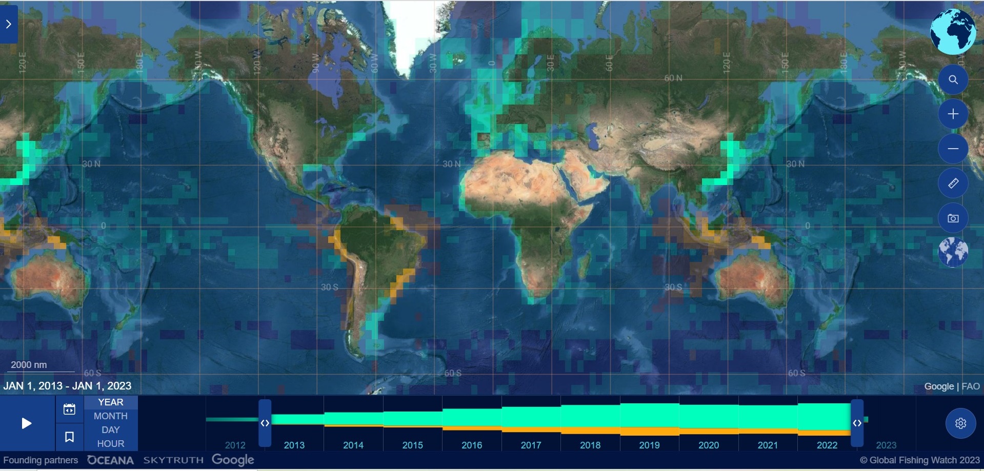
Figure 2: Global Fishing Activity 2013 - 2023[14]
Autonomous Vessels. Recent years have witnessed an explosion in the use of autonomous/ robotic vessels, both over the sea and undersea, for repairs of oil platforms, monitoring of undersea cables and pipelines, salvage and covert surveillance. Monitoring the movement of these vessels is important, not just safety of other vessels at sea, but also for national security of coastal states. The recovery of an unmanned underwater glider of Chinese origin in Indonesian waters in December 2021 underlined the dangers of such vessels.[15]
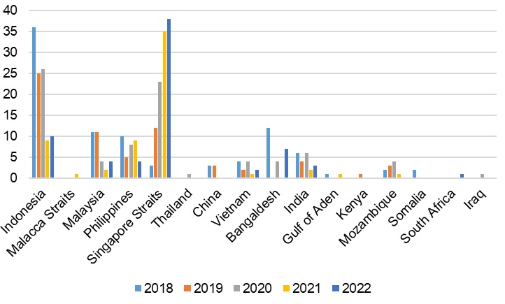
Fiugure 3: Trends of Piracy & Armed Robbery in the Indo-Pacific[16]
Piracy and Armed Robbery. While piracy in the region has witnessed a downward trend over the past decade, some areas continue to be afflicted by incidents of armed robbery as seen in Fig 3. However, since the political and economic conditions on land in Somalia (and now also in Yemen), which led to the rise in piracy in the first place, remain grim, withdrawing the maritime forces deployed for anti-piracy operations could lead to a resurgence of piracy.
Trafficking. Trafficking of contraband has been a bane of the maritime domain with drugs, humans and arms being the major items of such activity. Much of the drug traffic flow revolves around the north-western part of the IOR with a route that runs from the Makran Coast to Maldives, Sri Lanka, Seychelles and East Africa.[17] The western route from the southern and western coast of Myanmar, along the Andaman Sea and the Strait of Malacca to Southeast Asia is another such avenue.[18] The Pacific Islands have also become the “principal transit route” for the trafficking of drugs from Asia and South America to Australia and New Zealand.[19] Many of these routes are also used for human trafficking and arms smuggling. Much of this traffic is carried on board ships with flags of convenience and other craft with dubious registration, making identification and tracking difficult.
Natural Disasters.The Indo-Pacific lies astride geologically sensitive zones like the Pacific ‘Ring of Fire’ making it prone to natural disasters like volcanic eruptions, earthquakes and tsunamis. Climate change has further accentuated the damage that can be wrought by these natural disasters. Unfortunately, the IOR is also the locus of a large number of natural disasters, and is sometimes termed as the ‘World’s Hazard Belt’, being susceptible to climatological (cyclones and droughts), geological and tectonic (earthquakes and tsunamis), and hydrological (floods and tidal surges) disasters.[20] The establishment of warning systems to closely monitor this marmite geological activity requires cooperation amongst the Indo-Pacific littorals, considering the vast geographical impact of these events.
High Seas. The magnitude of the expanse of the seas can be understood in the agreement reached at the UN Biodiversity Conference (COP15) held in Montreal in December 2022.[21] The agreement underlined the fact that only 8 percent of marine areas are under protection and set a target of effective conservation and management of at least 30 percent of the world’s coastal areas and oceans by 2030. Of this, the area under protection in the high seas comprises only 1 percent. It was only on 04 March 2023 that the UN agreed on a framework text to ensure the conservation and sustainable use of marine biological diversity of areas beyond national jurisdiction, that is also being referred to as a ‘High Seas Treaty’.[22] Consequently, ensuring MDA over this vast domain will be an enormous effort, warranting regional and international cooperation.
Technology as an Enabler
Technology has always enhanced human efforts and even added new capabilities. While the maritime domain has been slow in absorbing new technology, the recent past has witnessed considerable efforts to increase the transparency of the seas. A host of technologies on board ships, ashore and on satellites have changed the way we see the maritime domain. Continuing advances in Information and Computer Technology (ICT) are also revealing hitherto unseen areas of maritime activity, which are described in succeeding paragraphs.
Automatic Identification System (AIS). The AIS was primarily intended to prevent ship-to-ship collisions while monitoring vessels and managing maritime traffic. The system is now also being deployed from airborne and space-borne platforms for vessel monitoring, providing a comprehensive maritime picture through dedicated services of various providers like the Maritime Safety & Security Information System (MSSIS). Notwithstanding, malign actors are continuously innovating to escape monitoring through ‘spoofing’ and switching off AIS, even as spoofing detection algorithms, which handle large volumes of data and geo-locate by time difference of arrival (TDOA), are helping to counter this activity. Continuing advances in technology will make this challenge even more complex, warranting closer international cooperation and sharing of resources.
Satellites. Satellites have helped extend MDA from near-coast to the high seas, albeit with temporal and spatial limitations on coverage. In addition to AIS transponders, satellites monitor electronic transmissions and use synthetic aperture radar (SAR) and electro-optical means, which enhances maritime surveillance, helping in tracking and identification of vessels at sea and countering AIS spoofing and dark shipping. Distributed Satellite Systems (DSS), involving a set of small satellites with different detection capabilities, working together to simultaneously cover larger areas, are also being used to overcome the spatial coverage limitations of a single satellite.
Autonomous Systems. Technological advances have enabled deployment of a host of sensors like AIS, satellite-enabled communication devices, IR cameras, etc. on autonomous buoys, fixed platforms and vehicles like undersea gliders to remotely monitor maritime regions. China’s Blue Ocean Information Network involves the deployment of a network of sensors and communications suites on board floating platforms as also buoys and fixed and re-locatable underwater sensors in the South China Sea. [23]
Web Based Information Platforms. A host of web-based information platforms, both governmental and non-governmental, are aiding MDA. These platforms fuse information from the AIS, open-source satellite data and others to provide a comprehensive picture on open-source maps/ charts. The Indian Ocean Regional Information Sharing & Incident Management (IORIS) is one such platform which was initiated by the EU under its Critical Maritime Routes (CRIMARIO) project to provide a “collaborative working environment to improve the understanding of the maritime domain and coordinate operations” for member countries.
Artificial Intelligence (AI). AI and Machine Learning (ML) have transformed the way humans work and the maritime domain is no exception. Utilisation of these technologies to detect patterns and anomalies, especially dark shipping and AIS spoofing will greatly aid MDA.[24] Coupled with currently available data on individual ships and their operating details, this technology can provide risk assessment and alerts of suspicious activity to stakeholders.
Image Recognition. This is also a spin-off from AI and ML based techniques which allows ‘finger printing’ of individual ships. Considering the ways vessels operating under flags of convenience can change their identities, image recognition can prove invaluable when deployed aboard aircraft or drones, or utilised to corroborate images from various sources to identify such actors.
Technologies mentioned above are only a small vignette of emerging developments across the world, which need to be continuously monitored for adaptation to the maritime environment. Existing systems like the IMO-mandated Long Range Identification and Tracking (LRIT) continue to co-exist along with these advances and remain a reliable source of information for security of shipping.
Architecture for MDA in the Indo-Pacific
Effort to develop an Indo-Pacific MDA network has witnessed a number of initiatives by various inter-governmental forums. While there are several sub-regional security arrangements in place, a pan-regional Indo-Pacific security architecture is not yet on the horizon. The existing sub-regional security arrangements in the Indo-Pacific are described below:-
- The Combined Maritime Forces (CMF) is a naval partnership of 35 countries intended to counter “illicit non-state actors” in the areas of the Persian Gulf, Gulf of Aden and the Red Sea. India joined this partnership in August 2022. The partners share a common platform for maritime information and utilise their assets deployed in the region to counter smuggling, suppress piracy and also respond to environmental and humanitarian incidents.[25]
- The European Union’s (EU) Operation Atalanta is intended to deter, prevent and repress piracy and armed robbery at sea; monitor fishing activities in the Horn of Africa and the Western Indian Ocean; combat drug trafficking and contribute to the arms embargo on Somalia, the illicit trade in charcoal, and IUU fishing.[26] The Maritime Security Centre – Horn of Africa (MSCHOA), located in Brest, is intended for ship owners to register their ship movements through the region to enable the EU NAVFOR to assess risks based on current situation.
- The Djibouti Code of Conduct is another multinational effort to repress piracy and armed robbery in the Western Indian Ocean and the Gulf of Aden. It also operates three Information Sharing Centres for sharing piracy-related information with its members.[27]
- The Contact Group on Piracy off the Coast of Somalia (CGPCS) was formed under the aegis of the UN, to coordinate efforts to bring an end to piracy off the coast of Somalia. The CGPCS has now has an expanded mandate to include IUU fishing and drug trafficking, and is called the Contact Group on Illicit Maritime Activities in the Western Indian Ocean (CGIMA-WIO).
- The EU funds another Regional Maritime Security Project (MASE) in East and South Africa wherein the INTERPOL is developing a regional mechanism for information sharing and the exchange of actionable data amongst nine countries of the region.[28] The MASE program also supports the Indian Ocean Commission’s (IOC) efforts to share information and coordinate actions, amongst member states, in fighting piracy and trafficking, as also in ensuring port safety, countering marine pollution and IUU fishing.
The latest initiative, and perhaps the most important one, has been the Indo-Pacific Partnership for Maritime Domain Awareness (IPMDA), which has been catalysed by the growth of China’s maritime presence in the Indo-Pacific. Over the past three decades, China has demonstrated increasing contempt for the international rule of law by encroaching islets and reclaiming reefs in the South China Sea (SCS), on which military bases have been built in pursuit of its Anti-Access Area Denial (A2AD) strategy. It has also increased its naval presence in the IOR over the past two decades and established its first overseas military base at Djibouti in 2017. The promulgation of the Belt and Road Initiative (BRI), especially its maritime arm, Maritime Silk Road (MSR) has led to a manifold increase in its maritime presence and involvement in maritime infrastructure projects from the South Pacific to Southeast Asia, South Asia, Africa and Europe. The unprecedented maritime build-up of the PLA Navy has made it the largest maritime force in the world. Supported by one of the largest world’s merchant shipping fleets, coast guard and maritime militia, China’s growing maritime strength has led it to increasingly use aggression to further its interests, as evident by the unilateral restrictions imposed on freedom of navigation and over-flight in areas of its choosing; use of force to enforce its maritime claims against other SCS littorals; daily intrusions into Taiwanese air and sea space in the recent past; and periodic threats to unite Taiwan by force.
Charting the Future of the IPMDA
The critical need to enhance the quality of MDA in the Indo-Pacific led to the Indo-Pacific Partnership for Maritime Domain Awareness (IPMDA), which was unveiled at a meeting of the leaders of the Quad in Tokyo on 24 May 2022. The stated aim of the IPMDA is to enable partner nations to fully monitor the region, which will in turn, uphold the aim of a “free and open Indo-Pacific”. IPMDA will build a faster, wider and more accurate maritime picture of near-real-time activities in partners’ waters. This common operating picture will integrate three oceanic regions – the Pacific Islands, Southeast Asia and the Indian Ocean – the South China Sea was not mentioned, probably so as not to “offend” China. This will allow the tracking of “dark shipping” and other “tactical level” activities, such as rendezvous at sea by criminal actors – drug traffickers for example; as also respond to climate and humanitarian events, and protect their fisheries. This is intended to be accomplished by:-[29]
- Harnessing Commercially-available Data using Existing Technologies. This will be achieved through a combination of AIS and radio-frequency technologies, which can provide an unprecedented “common thread” of activities. Being unclassified in nature, this is will also be shared with partners beyond the Quad. Future technologies will also be explored to remain a cutting edge partnership that promotes peace and stability throughout the region.[30]
- Extending Support for Information-sharing across Existing Regional Fusion Centres. These will include the Information Fusion Centre-Indian Ocean Region (IFC-IOR) in India, the Information Fusion Centre Singapore, the Pacific Islands Forum Fisheries Agency in the Solomon Islands, and the Pacific Fusion Centre based in Vanuatu, both of whom are supported by Australia.[31]
The initiative is especially important in the context of China which enacted two laws in 2021 – the Data Security Law and the Personal Information Protection Law – which allows their vessels to turn off their AIS transponders in certain areas and thereby protects the positions of Chinese-flagged vessels and their Maritime Militia. China has stated that foreign intelligence agencies use AIS data to “have a comprehensive grasp of the number of ships, cargo volume, and export data” in Chinese ports. It goes on to state that “the economic intelligence extracted from the data cannot be ignored” and that “espionage and intelligence agencies have recklessly seized important data resources in (China’s) related fields, causing serious harm to national security”. In a February 18 2022 press release by Unseen Labs, a satellite company that specialises in tracking and identifying radio frequency (RF) transmissions from space stated that more than 60 percent of vessels close to the Chinese coast were not available on AIS but had been identified based on their RF signatures. The company also observed the widespread use of AIS spoofing with the positions of several merchant ships appearing over land.[32] This development compounds the difficulties of identifying vessels at sea, which was already complex due to the facility available for merchant ships to operate under “flags of convenience”; the fact that many vessels either deliberately or due to other reasons do not carry mandated electronic identification equipment; and vessels under 12 metres in length not being required to carry any identification apart from basic navigation lights. To achieve the stated aims of the IPMDA, a few recommendations are contained in subsequent paragraphs.
Technology-related Issues. The IPMDA has correctly identified technology as a key enabler of the initiative. Consequently, technology-related issues related to identification of ‘dark vessels’, collaboration and interoperability will need to be addressed on priority, as follows:-
- Identification of Dark Vessels. MDA systems in Quad countries already collaborate in sharing information on “white shipping” and also have information sharing arrangements with several other countries and multinational organisations. It is essential for Quad member countries to share resources, invest in innovative technologies and digital public goods and build the capability and capacity of member countries, as also selected partner countries of the grouping. Publicly available commercial information sharing technologies like First Alert or SeaVision, C4ADS, the Naval Research Lab PROTEUS system, Japan’s MDA Situational Indication Linkages (MSIL), and several others, are already being utilised to harness information through data analysis tools to sieve through reams of data, including the internet, social media, blogs, audio transmissions and the deep web.[33] These technologies, and those that emerge subsequently, fill critical gaps in MDA and need to be harnessed to the IPMDA.
- Need to Ensure Interoperability in Operating Systems to allow Seamless sharing of MDA. Currently, MDA systems of Quad countries work on proprietary software and are hence not able to talk to each other. While the US, Australia and Japan are likely to have similar or compatible systems, India will have dissimilarities due to the independent nature of its defence policy. To ensure true interoperability between partner countries the IPMDA needs to ensure detection, data management and operating software powered by artificial intelligence through compatible systems, or else by providing requisite interfaces between differing systems.
- Address IT Vulnerabilities in Maritime Domain. Since MDA systems are software-based, the need for cyber security become even more important as the complexity and physical size of the network increases due to inter-connection between partner nations. With China, in particular, acquiring ever more sophisticated cyber warfare capability, the safety of MDA systems need to be continuously strengthened and regulated. /li>
- Create a Working Group on MDA-related Technologies. Due to the central importance of technology in building IPMDA, and especially in view of the issues brought about above, a dedicated ‘technology working group’ needs to be created under the IPMDA to discuss current and future issues related to technology. This is especially important as surveillance technologies, software and innovations are constantly evolving and cyber security threats are ubiquitous.
Capability and Capacity Building. There is a need for Quad countries to collaborate in capability and capacity building in MDA. For example, India’s acquisition of the P8I long range maritime reconnaissance aircraft from the US in 2008, the lease of the unarmed Sea Guardian long range drones for maritime surveillance in 2020 and the supply of customised Raytheon software for India’s Information Fusion Centre in 2013, have all greatly enhanced the quality of MDA available to the Indian Navy. This needs to be carried forward to sharing of new technologies, platforms and surveillance systems. Similarly, human resources involved in operating MDA systems need to be trained in using MDA software, and updated with advancements in technology, where again resources can be shared. Training of other human resources involved in implementing maritime security, such as legal experts and law enforcement agencies, also needs to be undertaken under the aegis of the Quad.
Conduct of Multilateral Exercises. Multinational MDA exercises need to be held regularly between Quad partner countries. These would supplement existing exercises, such as those held as part of the Southeast Asia Cooperation and Training (SEACAT) exercise, and those organised under the aegis of the United Nations Office on Drugs and Crime (UNODC) to support MDA through the Global Maritime Crime Programme (GMCP). Unlike SEACAT, which comprises 21 partner countries, and the GMCP, which involves all UN member countries, smaller groupings such as the Quad, can share more sensitive information and engender closer collaboration. Exercises to train human resources of both member and partner countries at sea, for example in Visit, Board, Search and Seizure (VBSS) exercises, will also help build inter-operability and expertise in member maritime agencies. Multinational exercises against common threats will also help in planning the optimum deployment of resources to handle various contingencies in different geographical regions.
Greater Sharing of Intelligence. IPMDA member countries Australia and Japan are treaty allies of the US under the ANZUS and the US-Japan Security Treaty, and thereby would have a very high level of intelligence-sharing between their security establishments. There are other intelligence alliances between the US and Australia (as also Canada, New Zealand and UK) such as the Five Eyes alliance. While India is not a treaty ally of the US, IPMDA offers scope for greater sharing of intelligence of interest to India, especially relating to China. This should be encouraged under the IPMDA, wherever it relates to building MDA.
Harmonising Maritime Legal Regimes/ Provisions. While detection, analysis and tracking of bad actors is the first step, interdiction of nefarious actors by cueing maritime forces requires legal mandates to be harmonised. Currently, various legal regimes governing the oceans, such as UNCLOS, the 1988 SUA convention and the 2005 Protocol to the SUA convention, approaches to dealing with piracy and terrorism, as also various non-proliferation initiatives such as the PSI, all have different interpretations and varying acceptance by Quad member countries. While this is not an insurmountable obstacle to multinational maritime security operations by the Quad, it does create situations where such differences affect the cohesiveness of the grouping. It is, therefore, preferable that existing differences be targeted to achieve harmony between Quad member countries, or at the very least, a common understanding be arrived at, so that it does not impact future multinational operations.
Aim to Achieve Four-dimensional MDA (4DMDA) in the Future. [34] The IPMDA needs to be expanded over time to include undersea and air & space domain awareness, in addition to the surface picture at sea. This is necessary as the partnership of Quad countries, while not being termed as a military alliance, may eventually have to face the ultimate test of a military conflict. Even if such a conflict does not arise, the partnership and IPMDA needs to be able to deter a military conflict by making the maritime domain as transparent as possible, which as such is its principal objective today. In a possible conflict with China of any of the member countries of the Quad, transparency of the underwater, air and space dimensions of the maritime domain will be critical for victory. The IPMDA will be an ideal platform to achieve 4DMDA, as smaller groups can engender information sharing of greater sensitivity. The ultimate aim should be to achieve sensor-to-shooter integration between Quad partner nations. This might seem like a “bridge too far” today, but if achieved, will in itself be the biggest deterrent to future conflicts, and hence needs to be seriously deliberated.
Conclusion
While not stated explicitly, there is no doubt that the IPMDA is primarily aimed to curb China’s maritime dominance and current ‘free run’ in the Indo-Pacific. For example, 95 percent of IUU fishing in the IOR[35] is done by Chinese fishing boats. China’s Coast Guard and its Maritime Militia are also the principal executors of China’s grey zone tactics, especially in the SCS and East China Sea. Such malign activities could proliferate to other oceanic areas if actions to deter them are not taken. This is where the IPMDA will play a critical role by “naming and shaming” China. China’s military strategy today envisages achieving “Information Dominance” followed by “precision strikes on strategic points” and “integrated joint operations” to gain victory in war. For China, the IPMDA brings concerns that the initiative will hurt not only its reputation by revealing its unlawful activities at sea, but also blunt its strategy of information dominance due to information sharing between Quad nations[36] during war or in times of crises.
IPMDA, therefore, has the potential to nudge the Quad into the direction of a de facto military alliance, despite public denials to this effect. Such an alliance (or issue-based alignment, as India would like to call it) has become inescapable due to the fact that China’s maritime strength cannot be adequately countered by one country alone, and only “coalitions of the willing”, preferably between democracies, will be able to prevent China’s future domination of the Indo-Pacific.
KW: managing maritime environment, maritime security issues, Indo-Pacific complexities, MDA architecture, maritime traffic, future of IPMDA
References
[1] “Ensuring Secure Seas: Indian Maritime Security Strategy”, Integrated Headquarters, Ministry of Defence (Navy), 2015, 55.
[2] “Critical Minerals: Global Supply Chains and Indo-Pacific Geopolitics”, The National Bureau of Asian Research, Special Report No102, December 2022, https://www.nbr.org/publication/securing-critical-mineral-supply-chains-in-the-indo-pacific-a-perspective-from-australia/, accessed 10 Jan 23.
[3] “The State of the World’s Fisheries and Aquaculture: Towards Blue Transformation”, Food and Agriculture Organisation of the United Nations, 2022, www.fao.org/3/cc0461en/cc0461en.pdf, accessed 15 March 2023.
[4] “One Hundred Ports – 2021”, Lloyd’s List, https://lloyds-list.maritimeintelligence.informa.com/-/media/lloyds-list/images/top-100-ports-2021/top-100-ports-2021-digital-edition.pdf, accessed 10 March 2023.
[5] “Indo-Pacific Strategy of the United States”, The White House, February 2022, https://whitehouse.gov/wp-content/uploads/2022/02/U.S.-Indo-Pacific-Strategy.pdf, accessed 12 March 2023.
[6] “The EU strategy for Cooperation in the Indo-Pacific”, European Commission, 16 Sep 21, https://www.eeas.europa.eu/sites/default/files/jointcommunication_2021_24_1_en.pdf, accessed 15 March 2023.
[7] “Japan’s Effort for a ‘Free and Open Indo-Pacific’”, Ministry of Foreign Affairs of Japan, March 2021, https://www.mofa.go.jp/files/100056243.pdf, accessed 12 March 2023.
[8] “Address by External Affairs Minister, Dr. S. Jaishankar at the Chulalongkorn University on ‘India’s Vision of the Indo-Pacific’'', Ministry of External Affairs, India, August 18, 2022, https://www.mea.gov.in/Speeches-Statements.htm?dtl%2F35641%2FAddress_by_External
[9] “International Arms Transfers”, SIPRI, https://www.sipri.org/research/armament-and-disarmament/arms-and-military-expenditure/international-arms-transfers#, accessed 14 Mar 23.
[10] “We Keep Close Watch: Navy Chief on Chinese Ships in Indian Ocean”, NDTV, 03 December 2022, https://www.ndtv.com/india-news/we-keep-close-watch-on-chinese-ships-in-the-region, accessed 30 March 2023.
[11] “Revised Guidelines for Onboard Operational Use of Shipborne Automatic Identification Systems”, International Maritime Organisation, 14 December 2015, https://wwwcdn.imo.org/localresources/en/OurWork/Safety/Documents/AIS/Resolution%20A.1106(29).pdf, accessed 14 Mar 23.
[12] “Improving Access to Maritime Data and Analytics”, Global Maritime Traffic, 2022, https://globalmaritimetraffic.org/gmtds.html?$root.map.zoom=3&$root.map.center={%22lat%22:-1.6100297087211821,%22lng%22:119.29687857627869}&$root.projectionSelect=%22EPSG:3857%22, accessed 14 Mar 23.
[13] “The Illegal Unreported and Unregulated Fishing Index”, Global Initiative Against Transnational Organised Crime”, December 2021, https://globalinitiative.net/analysis/iuu-fishing-index-2021/, accessed 15 January 23.
[14] “Global Fishing Watch”, https://globalfishingwatch.org/map/?latitude=14.710691278381958&longitude=-0.7539177346349106&zoom=0.8384885195072126&start=2013-01-01T00%3A00%3A00.000Z&end=2023-01-01T00%3A00%3A00.000Z&sidebarOpen=false&dvIn[0][id]=basemap&dvIn[0][cfg][basemap]=satellite, accessed 14 March 2023.
[15] “Indonesian Fisher Finds Drone Submarine on Possible Covert Mission”, The Guardian, 31 Dec 21, https://www.theguardian.com/world/2020/dec/31/indonesian-fisher-finds-drone-submarine-on-possible-covert-mission, accessed 04 January 2023.
[16] Compiled utilising data from the IMB Annual Piracy Reports.
[17] “Drug Trafficking on the Southern Route and Impact on Coastal States”, Indian Ocean Forum on Maritime Crime & UNODC, 29 October 2016, http://www.southernroute.org/download/Drug%20Trafficking%20on%20the%20Southern%20Route.pdf, accessed 10 March 2023.
[18] Asyura Salleh, “Illicit Maritime Drug Trafficking as an Evolving Threat to Southeast Asia’s Maritime Security”, Asia Maritime Transparency Initiative, 31 January 23, https://amti.csis.org/illicit-maritime-drug-trafficking-as-an-evolving-threat-to-southeast-asias-maritime-security/, accessed 10 March 2023.
[19]Jose Sousa-Santos, “Drug Trafficking in the Pacific Islands: The Impact Of Transnational Crime”, The Lowy Institute, 16 Feb 2022. https://www.lowyinstitute.org/publications/drug-trafficking-pacific-islands-impact-transnational-crime, accessed 10 March 2023.
[20] “Disaster Risk Management”, IORA, 2017, https://www.iora.int/en/prorities-focus-areas/disaster-risk-management, accessed 25 March 2023.
[21] “COP15 Ends with Landmark Biodiversity Agreement”, UN Environment Programme, 20 December 2022. https://www.unep.org/news-and-stories/story/cop15-ends-landmark-biodiversity-agreement, accessed 10 January 2023.
[22] “UN Delegates Reach Historic Agreement on Protecting Marine Biodiversity in International Waters”, United Nations, 05 March 2023, https://news.un.org/en/story/2023/03/1134157, accessed 06 March 2023.
[23] “Exploring China’s Unmanned Ocean Network”, CSIS, 16 June 2020, https://amti.csis.org/exploring-chinas-unmanned-ocean-network/#, accessed 25 March 2023.
[24]Matthew E. Alese, “Maritime Domain Awareness through the Characterization of Ship Behavior with AIS Data”, Defence Technical Information Center, June 2022. https://apps.dtic.mil/sti/pdfs/AD1184733.pdf, accessed 10 January 2023.
[25] “Combined Maritime Forces”, CMF, https://combinedmaritimeforces.com/, accessed 15 March 2023.
[26] “European Union Naval Forces Operation Atalanta”, EUNAVFOR Operation Atalanta, https://eunavfor.eu//, accessed 15 March 2023.
[27] “The Djibouti Code of Conduct”, IMO, https://www.imo.org/en/OurWork/Security/Pages/Content-and-Evolution-of-the-Djibouti-Code-of-Conduct.aspx, accessed 15 March 2023.
[28] “The Maritime Security Programme”, INTERPOL, https://www.interpol.int/en/Crimes/Maritime-crime/Port-Security-Project, accessed 15 March 2023.
[29] “Fact Sheet: Quad Leaders’ Tokyo Summit 2022”, The White House, 23 May 2022, https://www.whitehouse.gov/briefing-room/statements-releases/2022/05/23/fact-sheet-quad-leaders-tokyo-summit-2022/, accessed 27 March 2023.
[30] Ibid.
[31]Ibid.
[32]Brett Tingley, “Scores of ‘Dark Vessels’ Belonging to China’s Maritime Militias Are Operating in Contested Waters”, The War Zone, 22 February 2022, https://www.thedrive.com/the-war-zone/44390/scores-of-dark-vessels-belonging-to-chinas-maritime-militia-are-operating-in-contested-waters, accessed 29 March 2023.
[33] Jasmin Alsaied, “How to Make the Indo-Pacific Partnership for Maritime Domain Awareness Work”, The Diplomat, 11 October 2022, https://www.thediplomat.com/2022/10/how-to-make-the-indo-pacific-partnership-for-maritime-domain-awareness-work/, accessed 29 March 2023.
[34]Irvin Lim Fang Jau, “Comprehensive Maritime Domain Awareness: An Idea Whose Time Has Come”, S. Rajaratnam School of International Studies, Singapore, 16 October 2007, https://www.rsis.edu.sg/wp-content/uploads/rsis-pubs/WP141.pdf, accessed 29 March 2023.
[35]2022, China’s Role in the Exploitation of Global Fisheries: Issues for Congress, Congressional research Service, https://crsreports.congress.gov/product/pdf/R/R47065/1, accessed 31 March 2023.
[36]Zhang, R., 2022, The Quad, China and Maritime Domain Awareness in the Indo-Pacific, Australian Institute of International Affairs, https://www.internationalaffairs.org.au/australianoutlook/the-quad--china-and-maritime-domain-awareness-in-the-indo-pacific/, accessed 31 March 2023.
(The paper is the author’s individual scholastic articulation. The author certifies that the article/paper is original in content, unpublished and it has not been submitted for publication/web upload elsewhere, and that the facts and figures quoted are duly referenced, as needed, and are believed to be correct). (The paper does not necessarily represent the organisational stance... More >>

-

Introduction The northeast region of India has been inflicted
-

Indian foreign policy under the Modi government has been characte
-

The general elections for the National Majlis (Parliament) of Mal
-

India possibly can boast of having one of the largest (nearly 35
-
Following the visit of an Indian delegation to Afghanistan in Mar
-
The plenary sessions of the Chinese People’s Political Consulta
-

Background Chief of Army Staff (COAS) of the Indian Army, Gene
-

Premise This work attempts to analyse the following premise:-
Post new comment