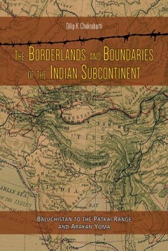
Prof. Dilip Chakrabarti has undertaken a stupendous task of studying and recording the borderlands and boundaries of the sub-continent right from the Hindu Kush and Karakoram through Chitral, Gilgit, Hunza, Ladakh, and Arunachal Pradesh upto the Arakan Hills in Myanmar. This study delves into the geographical, historical, religious and economic interaction and complexities of the borderlands, which have been a zone of interaction through history. Whereas the British took interest in exploring, mapping and demarcating the borderlands in Iran and Afghanistan, northern frontiers did not receive attention due to the British priority of appeasing China to keep Russians at bay. Prof. Chakrabarti draws attention to the importance of Iran and the route from Zabul and Zahidan to Mshed, which has now assumed importance due to the connectivity between Afghanistan and Central Asia through Chabahar port of Iran. Mention has been made of the sway of Hindu Shahis of Kabul. I may point out here that a Shiva temple existed on a hill in Kabul. It is still in the memory of the people of Kabul who call it as Joy-i-Sheer (milky stream). Few years ago I was in Kabul for about a week and from a distance I could feel some sacredness about this hill. I could not resist asking Dr. Mirwaiz Balkhi (now Education Minister in Afghanistan) about it, and he confirmed it to be the site of an old Shiva temple where milk flowed in a stream.
Prof. Chakrabarti rightly points to the Wakhan corridor as the dividing line between Tajikistan and Gilgit-Baltistan. I have travelled up to Langar- the last village of Wakhan Corridor (coming from Kulyab,Khorog, Ishkashim , Julandi etc.) and have seen myself Gilgit just 14 kms. across the Wakhan corridor from that point. One needs to imagine the catastrophic implications of the loss of Gilgit-Baltistan to India in 1947-48 in geopolitical and strategic terms. We not only lost a vantage position at this frontier, but we have been deprived of the direct overland access to Central Asia through Wakhan and Tajikistan, which has marginalised India’s role and position in Central Asia quite substantially.
Prof. Chakrabarti has arrayed the wealth of archeological and historical evidence to demonstrate the closeness of India-Central Asia interaction both in cultural, artistic and economic realms. He has detailed the passes on the Hindu Kush and routes from Ladakh to Tibet and Xinjiang. Chapter 4 outlines the spread of Buddhism in Central Asia and points to the existence of several Buddhist sites in Turkmenistan, Uzbekistan, Kyrgyzstan and Kazakhstan. Here, it is pertinent to point out that Dunhuang caves in China have been properly maintained and studied, attracting adequate international attention. So much so that 9 million tourists visited Dunhuang caves in the year 2018. But the remnants of Buddhist sites in Central Asia are in shambles and cry for attention. Though we in India are never tired of stating the close and rich historical-cultural ties with Central Asia, we have not initiated any practical steps for the preservation and maintenance of such evidence of Indian imprint in Central Asia. Tamgaly Tas in Kazakhstan, ruins of a Buddhist stupa and two Kushan forts in Tajik Badakhshan, Buddhist sites in the Chu valley-Ak Beshim, Krasnaya Rechka, Balashagun etc. call for urgent attention. In fact tractors ply over the main Buddhist heritage site lying underground in Balashgun in Kyrgyzstan. We spend huge sums annually on the functioning of Indian Cultural Centres in the Central Asia, but we have not thought of erecting a fibre glass cover at Tamgaly Tass and other Buddhist sites, not to speak of the restoration of the Kushan forts in Tajik Badakhshan.
Boundary from Ladakh to Arunachal Pradesh, which is overlooked by Tibet, has been dealt in detail in Part II of the book. Prof. Chakrabarti is right in saying that Tibet has been traditionally linked more to Indian Himalaya through trade, Buddhist connection and people to people contacts, rather than to China. In fact Chinese tea etc. reached Tibet via Kashgar-Yarkand-Leh-Gartok-Lhasa route, besides from Yunnan-Sichuan route. The Treaty of Tingmosgang signed in 1684 “fixed the border at Lhari stream, flowing into the Indus south-west of Demchok”
The British Indian government sent two commissioners Alexander Cunningham and Vans Agnew to Ladakh in August 1846 to “ascertain the ancient boundaries between Ladakh and Tibet and to lay down the boundary between the newly acquired British possessions in the Hills and Gulab Singh’s territory”. 3Though the British sought cooperation of the Tibetan and Chinese officials to the joint demarcation of the Ladakh-Tibet border, both the Chinese and Tibetans evaded the issue, as they did not want to give access to the British for trade in Tibet. When the British commissioners arrived at the border at the end of August 1846, there were no Chinese officials. They were also met with the hostility of Tibetans. In fact the Chinese Viceroy at Canton, Key-ing wrote to the British Plenipotentiary at Hong Kong clearly stating that “a liberalised Chinese trade policy in Tibet would violate the Treaties of Nanking, which gave the British special rights on five Chinese ports.”4 As regards the border issue, Key-ing stated that “the borders of these territories have been sufficiently and distinctly fixed so that it will be best to adhere to this ancient arrangement”. 5 Cunningham confirms that “with Rudok on the east there has been a long peace. The boundary is well defined by piles of stones, which were set up after the last expulsion of the Skopo or Mongol hordes in 1687 AD.” 6 Cunningham adds that “a large stone was then set up as a permanent boundary between the two countries, the line of demarcation being drawn from the village of Dechong (Demchok) to the hill of Karbones.”7 So the point is, has post-independent India taken any steps to protect, maintain and monitor the presence or shifting of these stones as boundary markers.
Prof. Chakrabarti has examined in detail the geographical, historical, economic and religious interactions between Indian bordering areas and geographical zones lying outside. It is relevant to point out here that China right from Han times used the ancient Silk Road to reach out to Persia, Central Asian Khanates etc. more for political than economic considerations. China used trade and even subsidies on trade as a means to extend their diplomatic and geopolitical influence in the outlying territories. In contemporary times, China has used this concept to promote the old Silk Road, pursued a policy of constructing the Eurasian Land bridge, followed it up with One Belt One Road (OBOR) (2013-16), and has now focused on Belt and Road Initiative (BRI) (2016 onwards). Thus China has successfully executed its plan of extending economic and political influence across Central, South and West Asia and even beyond in Europe and Africa.
Implications of the study by Prof. Chakrabarti need to be followed up by taking concrete steps, keeping in view the current and upcoming challenges to our sovereignty on our borders in the north and east. Our borderlands are under great stress due to open challenges to our sovereignty in Kashmir, Chinese position on our northern and north-eastern frontiers. Whereas political goodwill and tranquility are essential for peaceful boundaries, harmony and cross-border cooperation, settlement of borders is necessary to resolve the border disputes. Borders need to be formally agreed, well documented, surveyed and recorded, demarcated, maintained and well managed. Boundary markers/monuments have to be erected, maintained and borders monitored.
The symbolic characteristics of territory are used as a means of consolidating the link between national identity and a specific space. Sadly, the great and ancient monuments of Indian civilisational presence dotting the entire Valley of Kashmir, are being obliterated with a clear objective of erasing the concrete historical-cultural evidence of Indian civilisational presence in Kashmir. Over 200 old temples have been destroyed and scores of old Sufi shrines/dargahs have been burnt down. Here one may point out that the High Court of Pak-occupied Kashmir in one of its judgements asked the government there to take steps to preserve and maintain the ruins of ancient Sharda temple in Neelum Valley, Muzaffarabad. Indian institutions particularly the Archeological Survey of India have not done their job of forging the territory – identity bond using the abundant tools of archaeology and history available. Instead the process of territorial alienation from the Indian mainstream has been fostered through text books, revised /doctored history writing. One can undertake/ organize field trips to places of historical-cultural significance. What we find is that tour operators of Kashmir have changed their travel itineraries for foreign and even Indian tourists, describing Shankracharya temple as Takht-i-Suleman, Hari Parbat as Koh-i- Maran, ancient city of Srinagar (founded by Ashoka) as Shahr-e-Khas. Similarly the battle sites and memorials of martyrs need attention. Maqbool Sherwani was killed by Pak raiders at the age of 19 years, in Baramulla on 7 November 1947, as he delayed the advance of Pak troops to Srinagar by leading them astray. Crucifixion of Sherwani is recorded in a small plaque in Baramulla Cantonment. Similar is the case with Brigadier Usman, who was killed in July 1948 in Nowshera while fighting Pak troops. Both Sherwani and Usman are rare symbols of heroism, patriotism and of India’s inclusive secularism. So concrete steps need to be taken to promote territorial symbolism which plays important part in the construction of national identity and consolidation of frontiers.
End Notes
- Dorothy Woodman, Himalayan Frontiers. London, Barrie & Rockliffe, 1969. p 20.
- A.H. Francke, Ladakh : The Mysterious Land (Reprint, Delhi, 1978), p. 113.
- Ibid. p 62.
- Ibid.
- Ibid.
- Alexander Cunningham, Ladakh. London, 1854. p 261.
- Ibid. pp 328-29.

-

Swadesh Singh's compelling work, “Modian Consensus: The Rediscovery of Bharat,” offers a riveting...
-
When a colonised nation gets rid of its masters, one of its first acts is to reclaim its...
-
Several studies have been conducted on different dimensions of strategic issues in different parts...
-
Pakistan Insights 2023 is the fourth in the ‘Pakistan Insights’ series brought out by the...
-
India and the Changing World breaks free from conventional boundaries, delving fearlessly into the...
-
The present book intends to highlight universal Vedic vision and provide an overview of ennobling...
-
The February 2021 military takeover in Myanmar has had adverse impact on the country`s political,...
-
PK Mallick, an Indian Army General, scholar warrior par excellence with his more than two decades...
Post new comment