
Introduction
Water is essential for the life in more than one ways. Besides the drinking purpose its centrality for the agriculture, in an agrarian society, is highly established. In this connection, it is important to note that water, particularly potable water, is finite. Also, besides drinking and agriculture purposes, substantial quantity of water is needed for the industry.
Demand and Availability of Water
It is interesting to note that while demand of water is ever increasing, the availability is reducing for a number of reasons. Some of the reasons are as follows:-
- Population of India has increasedfrom 340 million in 1947 to 139.3 million in 2021. Similarly, water availability which was 6042 cubic meters/capita/annum is around 1400 cubic meters/capita/annum today and is likely to become 1140 cubic meters/capita/annum by 2050. At macro level India is home to 18 percent population of the world and has just 4 percent of the global water. As internationally recognized, 1700 cubic meters of water /capita/annum is the threshold of a country to be a water stressed country, as such, India is already water stressed and racing towards becoming a water scarce country (1000 cubic meters/ capita/ annum).
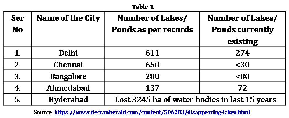
- Due to poor watershed management and land grab by land mafias, the system of local water bodies, village ponds and reservoirs are getting destroyed, with the implication that water availability is getting reduced locally and affecting the microclimate of the area. In this connection it would be relevant to take note of following table:-
Water Contamination
Around 80 percent of India’s water is severely polluted because people dump raw sewage, silt and garbage into the country’s rivers and lakes. About 80 percent of water reaching households leave as waste, thus generating a sewage of 61754 million liters/day (MLD). India as on date has a sewage treatment capacity of only 22963 MLD. Thus 62 percent of sewage gets discharged into the nearest water body. As a consequence, incidence of water-borne diseases including more serious ailments like cancer is increasing substantially each year. More than 1.5 million Indian children die from diarrhea. Out of the entire Indian population, experts predict that 40 percent of people may not have a connection to a clean water source by 2030.
Therefore, pollution of rivers is substantially reducing the availability of fresh water; besides available polluted water is becoming a source of growing number of water-borne diseases. It may be noted that between 2000 and 2010 China reduced its individual mortality rate from 30.1/1000 live births to 9.2/1000 live births by making massive investment in clean water infrastructure. It goes without saying that mortality ratereduces with improved quality of water and sanitation. In this connection following aspects need to be flagged:-
- Religious practices in India are adding to the water pollution. Immersion of religious idols and other offerings pollute the water.
- Encroachment of the river plains is further adding to the river pollution when open defecation as well as residual chemical manures of crops harvested in the river plains is adding to the pollution levels. In addition, floods which are increasingly becoming a regular yearly feature cause widespread destruction, and consequent pollution of the river waters.
- Ground water fed riversare becoming extinct due to poor crop pattern - many a times use of highly water intensive seeds. An example of such apathy is River Gomti in the state of Uttar Pradesh. This river originates from a Lake (Gomat Tal) in Pilibhit district of Uttar Pradesh. In last few years the local farmers have been growing a paddy variety known as Saath Dhan in and round Pilibhit. This variety of paddy consumes about 10 times more of water as compared to other varieties of paddy. As a result, not only the Gomat Tal has shrunk substantially but the river also has literally vanished for first 10-15 kms of its course. It gets rejuvenated in lower reaches when other tributaries join it.
Water Availability
Global warming and the climate change are affecting sustained availability of water in rivers, especially in the glacier fed north Indian rivers. In this connection, it would be relevant to note that lack of adequate infrastructure is allowing almost 92 percent of the rainwater to go waste as the existing infrastructure is capable to store only 8 percent of it. Reduced availability of water due to climate change is not only affecting us but is having a highly adverse effect on many of our neighbours. Today both the major rivers of northern China, Yangtse and Huang He, are having reduced water availability, and as such China is facing certain crisis of water availability in the basin of these two rivers. It is anticipated that the situation is likely to further deteriorate resulting into a large number of environmental refugees in China. China is trying to divert the water of Brahmaputra River in Tibet near the Great Bend to augment water supply in these water starved rivers. Similarly, reduced water availability in lower reaches of Indus in Pakistan has allowed the ingress of the sea water in Kotri area of Sindh into the Indus water making it saline in Sukkur area of Sindh province which is the traditional rice bowl of Pakistan. This phenomenon has affected the food security of that country.
Over-exploitation of ground water in Indo-Gangetic belt is lowering the water table alarmingly. Soil chemistry of this area is such that the ground water is now having Arsenic contamination and that is further affecting the availability of water. Need for water on the other hand is increasing due to following:-
- Agricultural crop pattern in India has changed substantially in recent times with more emphasis on growing only wheat and paddy which are highly water intensive. Coarse grains which were quite popular earlier, have gone in decline. In this connection only two exampleswould suffice. More and more use of dwarf seed for paddy from Bayer (erstwhile Monsanto Company) has increased the water demand many fold. Also, in recent times, highly water intensive cash crops like cotton, sugarcane and trees like poplar are becoming more popular, and all these have put more pressure on water demand. Following table puts in perspective the water requirement of various grains:-
- Poor building designs, wherein more water is needed for ablution. In this connection a major water requirement has come up in recent times due to the nationalresolve to end open defecations.
- Water required by industry. Whether road construction, building construction, textile industry and above all energy generation, are all water intensive. One small example would suffice. India has shell gas available in Indo-Gangetic plains at a number of points, but the amount of fresh water that is needed for its fracking is so much that India can ill afford to go for it. As such there is a need to find other possible ways for the energy conversion. Similarly, land required for large hydro-dams is difficult to be found by India due to its growing population pressure, and as such, a major source of cheaper means of energy conversion has to go a-begging.
- India is heavily dependent on coal based thermal energy conversion. This form of conversion is quite water intensive for many reasons. Firstly, Indian coal needs to be washed as it has very high ash content, and secondly, large water bodies are needed for cooling. It is well appreciated that as a driver of economic growth, sustained availability of adequate energy at affordable cost is a pre-requisite. However, in Indian context, conversion from the available indigenous resources is becoming challenging, and hence the gap between the demand and supply of energy is widening. One of the major reasons for this situation is non-availability of adequate amount of water. Such a yawning gap is making economic growth of the country quite challenging.

Geopolitics of Water in South Asia
In view of the above discussion, there is a definite need for adequate availability of water to meet India’s needs in terms of human consumption, agricultural needs and the smooth running of industry. However, as has been established in the above discussion, while the demand is rising, availability is shrinking. This growing mismatch is going to affect the quality of life, life sustenance, agriculture growth, and finally, availability of energy necessary for the economic growth. To find a way out there is a need to look beyond indigenous resources.
A look at the map of Indian Sub-Continent suggests that there are a number of international water channels wherein India is either a middle riparian or upper riparian state. Important international channels which originate in Tibet are Indus, Sutlej, Arun and Brahmaputra. In addition, India is an upper riparian in case of the rivers Jhelum, Chenab and Ravi in west and Teesta in east. In addition, there are a number of rivers which originate either in Nepal or Bhutan and India is the lower riparian state. International cooperation is therefore needed to harness the hydro-resources of countries of the South Asia.
In this connection the model adopted by Bhutan and India is worth emulating. India has developed necessary infrastructure in Bhutan after establishing the necessary special purpose vehicle and the power so generated is used by Bhutan while surplus power is sold to India. Bhutan has a potential to generate 30,000 MW of hydro-power but has a generation capacity of just 1,490 MW. According to the Indian embassy in Thimphu, hydro-power exports provide more than 40 percent of Bhutan’s domestic revenues, and that constitutes 25 percent of its gross domestic product.
This is one of the most successful model which is win-win for both countries. Bhutan has become almost a middle-income country and India is getting substantial amount of power in the eastern grid. Similarly, Nepal has a feasible potential of almost 43000 MW, but the current hydro-electric power cooperation is less than 50 MW. There are a number of hydro-electric projects in planning stage like Karnali-Chisapani, Mahakali-Pancheswar and Arun-III. As and when these projects get completed it would also be a win- win situation for both the countries.
Indo-Bangladesh Water Cooperation
The Ganges-Brahmaputra-Meghna mega-basin is the second largest hydraulic region in the world. It is also one of the most densely populated regions. Within this basin, fifty-four rivers cross the border between upstream India and downstream Bangladesh. Also, Brahmaputra River enters from East into Bangladesh. It is interesting to note that only bilateral agreement between the two countries is the Ganges Treaty of 1996 to share surface waters at the Farakka Barrage. There exists a large scope for further cooperation between the two countries, especially sharing of Teesta waters for the mutual benefit of the people of both the countries.
Need for Indo-Pak Water Cooperation
As far as Indo Pak water relations are concerned, there is treaty, namely the Indus Water Treatry-1960, which governs the water sharing relations between the two countries. As per this Treaty, water from three eastern rivers namely Beas, Ravi and Sutlej are being allocated to India with certain amount of water from the tributaries of these rivers being allocated to Pakistan. Pakistan also has its right on the waters from those rivers which flow into its territories. Pakistan, is on the other hand, is allotted waters from the three western rivers,namely, Chenab, Jhelum and Indus. India is authorized a very minimal amount of water from these three rivers with a concession fornon-consumptive and agricultural use of the waters from these rivers without impounding beyond the authorized limit.
Although there are a number of issues on equitable sharing of the water between India and Pakistan. But it is a testimony to the sagacity of the leadership of the two countries that despite various issues between the two countries the treaty has continued to be held steady; the Treaty is helping the two countries to steadily move on the path of economic growth. In this connection, it is worth noting that India is only a middle riparian in the case of Sutlej and Indus while the upper riparian is China. The latter, in contravention of the 1997 ‘United Nations Convention on the Law of the Non-Navigational Uses of International Watercourses’ is impounding water from these rivers without any reference to India and Pakistan, who are the lower riparian states.
It may be noted that China is not a signatory to this Convention. As such, China is going ahead with her plans for water utilisation from Sutlej and Indus. Her unilateral action is reducing the availability of water in Indus and to an extent in Sutlej, with the consequent impact on the economic growth of lower riparian states. It may also be appreciated that China is quite capable of using the waters from these rivers as a weapon. Case in point is the water release by her in Parichu River, a tributary of Sutlej, in 2000, and again in 2004, resulting in damage to the assets of Bhakra Beas Vidyut Board.
The Parichu Incident and its Implication
It is not very well known that on the early hours of August 1, 2000, a flash flood had occurred in the Parichu, which was carried into the Sutlej from a place called Khab on the border of Himachal Pradesh with Tibet. It happened at about 0100 hours on August 1 and reached the NathpaJhakri Project at about 0515 hours. Within a short span of time, the level of the River Sutlej rose by 15 meters and the water discharge rose suddenly from 1480 cumecs (cubic meter per second) at 0300 hours to 5100 cumecs by 0530 hours, coming down to just 1416 cumecs by 0900 hours. There was, however, no flood in River Spiti which joins the Sutlej near Khab.
According to one report by a team of engineers connected with the Bhakra Nangal Project, "the devastating flood which gained momentum as it passed down the river from the heights of Kinnaur district destroyed almost everything on its way including the costly infrastructure assets, thus pushing back the clock of development by several decades.” It resulted in a loss of lots of life and property, disrupting services such as power, water supply and telecommunication in the flood-affected areas of Kinnaur, Shimla and Mandi districts of Himachal Pradesh. More than 150 people were swept away, several were buried under the huge mass of rubble and the area remained inaccessible for several days. About 50 bridges from Khab to Sunni and about 50 km of the Hindustan-Tibet Road, the lifeline of the Lahul-Spiti district, were washed away. The damages to the highway had a tremendous impact on the economy of the area with apple, peas and other cash crops remained stuck in the area when these are normally exported.
The Nathpa Jhakri Project, then under construction, too was damaged by the backflow of the water in the tailrace tunnel. Tons of rubble and silt got accumulated on the generating units. The total loss because of the flood was estimated at Rs.2500 crores then.
An inquiry into the accident concluded that China never allowed Indian investigation team to visit the location from where water is believed to have originated in Tibet. The probable cause after consulting the satellite imageries was concluded to be a gracial lake outburst and a cloud burst at the same time in the catchment area of the Parichu in Tibet. The reason why the rest of India, particularly the Punjab cities and towns like Ludhiana did not feel the impact of this flash flood was that the Bhakra Dam's Gobindsagar Reservoir, with a capacity of 9868 million cubic foot, absorbed all the flood waters. Even in 2004, when a similar flash flood stopped generation of power at the Nathpa Jhakri Project, the Bhakra Beas Management Board had gained from the inflow into the reservoir.
China, by constructing a barrage across River Parichu in Tibet, has acquired the capability to use the accumulated water to manipulate water flow in Sutlej River at will and to cause damage to India’s water harnessing infrastructure with its consequent impact on the economy of Himachal Pradesh and Punjab.
River Brahmaputra: Immense Economic Promise
It has been reported in the Scientific American magazine of the United Sates in June 1996 that Chinese engineers had been telling the Chinese Academy of Sciences that the waters of Upper Brahmaputra could be diverted into the arid northwest region of China and the Gobi Desert through peaceful nuclear explosions. Some recent reports suggest that China indeed is working to divert the water of Yarlung Zangbo (the Brahmaputra as it is known in Tibet) for the said purpose. China is also planning a dam in Medog County near the Indo-China border, which will further reduce the water availability downstream of the dam. And that will impact a very large population in the state of Assam in India and Bangladesh.
There is however another fear that some volume of water of the Yarlung Zangbo could be diverted into the Arun River or the Gandaki in Nepal. It may be noted that both these rivers later flow into India, the former as part of the Sapta Kosi and the latter as the Gandak. Both rivers have been harnessed jointly by Nepal and India. Such diversions are likely to give handle to China to control the flow into these rivers with attended implications for the power generation as well as water utilization in the lower reaches, thus affecting agriculture in Nepal and India. China is also believed to have built a hydro-power dam on Karnali
(Ghaghara in India and Mapcha Khambab in Tibet) in Tibet few km from Nepal border which is a major source of water in Ganges.
While it is possible for China to misuse its geographical location, being an upper riparian, in the absence of any treaty between India and Nepal. But there is also a possibility of cooperation to harness the immense potential of the Brahmaputra as it takes a U-bend in Tibet towards Arunachal Pradesh and Assam, dropping almost 8000 feet in the process. Japan's Electric Power Development Corporation did a desk-top study of a possible Upper Brahmaputra cascade with a resulting dam South of Lhasa and a series of power stations below that, crowned by two alternative Tibet-to-Assam tunnel projects to generate 48,000 to 54,000 MW at one of other of these sites alone. The largest hydro-electric plant in the world today is the Three Gorges plant in China across the Yangtze with an ultimate installed capacity of 18,200 MW. The dam at Medog is going to generate 60 GW of energy.
Conclusion
Water remains a source of life and growth but increasingly it is becoming scarce due to a large number of reasons. That makes critical the necessity for the use of technology to enhance the availability, conservation as a practice to use the available resources optimally and international cooperation to optimize the available resources. India’s recently formed Ministry of Jal Shakti is therefore a step in right direction. However, more needs to be done in the domains of generating awareness among the common citizens to ensure conservation, leveraging technology to enhance availability, and developing a mechanism for international cooperation to optimally utilize common resources in the region.
The Government will have to formulate necessary policies for the better management of water resources and continuously review these policies to keep these aligned with the changing socio-political, geostrategic and techno-economic changes.
(The paper is the author’s individual scholastic articulation. The author certifies that the article/paper is original in content, unpublished and it has not been submitted for publication/web upload elsewhere, and that the facts and figures quoted are duly referenced, as needed, and are believed to be correct). (The paper does not necessarily represent the organisational stance... More >>
Image Source: Plateau Maps/Meltdown in Tibet

-

Indian foreign policy under the Modi government has been characte
-

The general elections for the National Majlis (Parliament) of Mal
-

India possibly can boast of having one of the largest (nearly 35
-

Following the visit of an Indian delegation to Afghanistan in Mar
-

The plenary sessions of the Chinese People’s Political Consulta
-

Background Chief of Army Staff (COAS) of the Indian Army, Gene
-

Premise This work attempts to analyse the following premise:-
-

Modi is the first and only Prime Minister to place before the peo
Post new comment