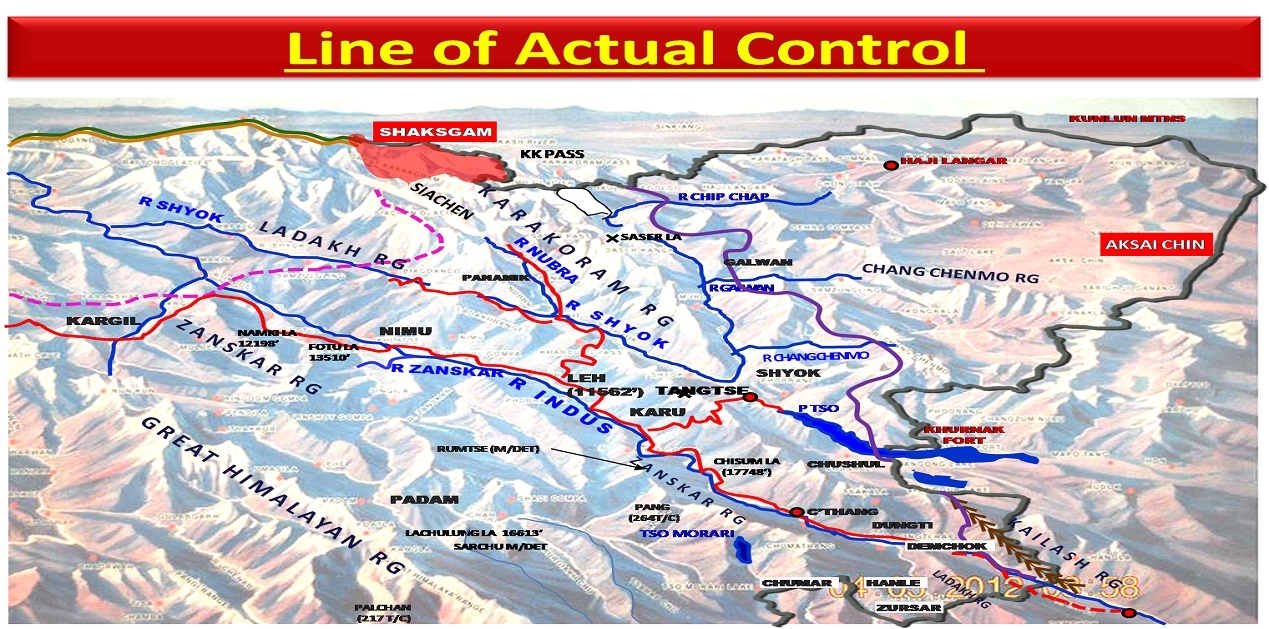
Though comparisons are odious, Line of Control (LOC) and Line of Actual Control (LAC) are chalk and cheese! The Karachi Agreement of 1949 delineated the Ceasefire Line (CFL), following directional paths in the absence of clear landmarks, by demarcating over 740 kms on the ground between Indian and Pakistan in J&K. Again the CFL was unambiguously delineated till it reached “…Chalunka (on the Shyok River), Khor, NJ 9842” whereupon it was designated “…thence North to the glaciers”. The successor to CFL, the LOC was delineated in accordance with Simla Agreement signed between India and Pakistan on 02 July 1972. Lt Gen PS Bhagat and Lt Gen Abdul Hameed Khan (Pak Army) prepared and signed two sets of maps, each set consisting of 27 map sheets formed into 19 mosaics. While the LOC was delineated and accepted by India and Pakistan up to point NJ9842, the Siachen Glacier was left unmarked. The LOC continued from NJ9842 “running Northwards to the glaciers”, gave birth to Actual Ground Position Line (AGPL) in 1984 – rest being history. Despite being well demarcated and delineated, the LOC has remained hot and tense, though post Kargil War of 1999, it has achieved a modicum of sanctity!
Au contraire, the Sino-Indian boundary has not been demarcated and delineated, with the Line oxymoronically termed the Line of Actual Control (LAC). History draws attention to the 1842 Treaty, to the ‘Lines’ that attempted to delineate the boundary between Ladakh and Tibet – the Ardagh-Johnson Line of 1897 and the Macartney–MacDonald Line of 1899, and the Shimla Conference of 1914. The first reference to LAC came in the 07 Nov 1959 letter of PM Zhou en Lai to PM Jawahar Lal Nehru, “… in order to maintain effectively the status quo of the border between the two countries, to ensure the tranquillity of the border regions and to create a favourable atmosphere for a friendly settlement of the boundary question, the Chinese Government proposes that the armed forces of China and India each withdraw 20 kilometers at once from the so-called McMahon line in the east, and from the line up to which each side exercises actual control in the west…”.
Again in 17 Dec 1959 letter, PM Zhou had stated that “…the reason for the present existence of certain disputes over the Sino-Indian boundary is that the two countries have never formally delimited this boundary and that there is a divergence of views between the two countries regarding the boundary. The Chinese Government holds that the so-called McMahon Line is wholly illegal… it is known to the world that the Simla Convention itself is void of legal validity.” The stark differences of opinion were evident in the exhaustive April 1960 Talks between PMs Nehru and Zhou in India, where the latter reiterated the LAC stating that “…the boundaries have to be defined in terms of latitude and longitude; but this was not done. The boundary line has to be fixed by negotiations. Although our boundary is not formally delimited or fixed, there exists a line of actual control. In the eastern sector, it is the McMahon line, and, on the western sector, the line is the Karakoram and Kongka pass.” Mr Shivshankar Menon has stated in his book ‘Choices: Inside the Making of India’s Foreign Policy’ that the LAC was “…described only in general terms on maps not to scale” by the Chinese. It obviously implies that without any demarcation or delineation that is without correlation of latitude and longitude, an LAC has indeed existed in a grossly fuzzy logic.
India and China engaged in Confidence Building Measures (CBMs) on the border with bilateral agreements signed in 1993, 1996, 2005, 2012 and 2013. The 1993 Agreement on Maintaining Peace and Stability stipulated that the two sides would not use force or threaten to use force and respect and obey the actual control line. Mr Shyam Saran has mentioned in his book ‘How India Sees the World’ that India had formally accepted the concept of the LAC when (PM) Rao paid a return visit to Beijing in 1993 and the two sides signed the Agreement to Maintain Peace and Tranquillity at the LAC. The reference to the LAC was unqualified to make it clear that it was not referring to the LAC of 1959 or 1962 but to the LAC at the time when the agreement was signed. To reconcile the differences about some areas, the two countries agreed that the Joint Working Group on the border issue would take up the task of clarifying the alignment of the LAC.
The 1996 Agreement laid down CBMs and was like a no-war pact stating that neither side shall use its military capability against the other side. It also prohibited any use of hazardous chemicals, conduct blast operations or hunt with guns or explosives within two kilometres of LAC. The 2005 Protocol laid down that the procedure to be followed if the border personnel of the two sides came face-to-face situation due to differences on the alignment of the LAC. The India-China Border Agreement of 2013 emphasised that neither side shall use military capability against the other side. With the experience of face offs over the years, a caveat was added that the two sides shall not follow or tail patrols of the other side where there is no understanding of the LAC.
Suffice it to say, the task of clarification of the LAC never fructified, though an attempt was made in 2002. Over a period of time newer areas of dispute emerged; in many areas during face-offs, the PLA increased its claims. Even the disputed areas along the border did not retain finality, with certain dynamism and regular increase by the PLA. The 1996 and 2005 Agreements that gave rise to the functional protocols and drills of face-to-face encounters of patrols were unable to cope with this newly arising claims and fresh areas.
It is evident that though the Chinese profess to have atavistic memories; these are highly selective and adjustable as it suits them. Deliberately China disallowed all attempts to fixate the LAC that is to demarcate and delineate, on ground and on maps that left situating domination of the LAC to events as they happened. Fast forward to current times, and came in the cataclysmic events of 2020 in recent fresh memory, that require no reiteration. As a first, nine Corps Commander Talks at Chushul/ Moldo in Eastern Ladakh were held. The Ninth talks recently have been in “positive, practical and constructive” environment, however with limited tangible success. It has however led to an eyeball to eyeball situation along the LAC in the winter of 2020/2021, and apprehensions for the summer of 2021. Apparently, China desires to restrict the disengagement to very limited areas North and South of Pangong Tso, while a more comprehensive solution across the entire front and some assurances for the future have been rightly sought by India. Future of the talks cannot be prognosticated; the situation as it is seems to have firmed in!
Contextually, it is essential to recall the aftermath of Philippines and China standoff of 2012. China had then seized control of Scarborough Shoal, near the main Philippine island of Luzon, in June 2012, after a Philippine Navy vessel tried to arrest Chinese fishermen found illegally hauling giant clams there. The Shoal was then under Philippines control and the Chinese actions were in violation of 2002 pact on the South China Sea between China and ten Southeast Asian nations. The United States affirming its alliance obligations under the US-Philippine Mutual Defense Treaty had mediated to resolve the standoff, and seemingly brokered a “face-saving” deal by asking both nations to pull out their ships. Honouring this, the Philippines withdrew, but despite commitments to de-escalate, China reneged and kept its ships at the Shoal. It later even brushed aside the decision of the International Court which upheld the sovereign rights of the Philippines. Obviously the Scarborough Shoal (and other reefs etc under Shansha City of Hainan Province) is being created into a base with habitation for civilian population.
How does this example become relevant in Indian context? The issue is of deliberate, deep thought that leads China to surreptitiously occupy areas, create infrastructure and cause demographic changes along disputed areas. China is a master in furtively salami slicing, and then happily gulping the salami without remorse or challenge! With the LAC kept deliberately vague, new attempts to change demography and create additional infrastructure are apparent. The G216, a new highway will connect Xinjiang to Tibet (Kyirong on Tibet-Nepal border), with interconnections with G219. China has built 965 relocation sites and relocated over 2,50,000 people. With the recent evidence of a quick-time construction of village at Longju, and in Nepal and Bhutan, what will follow will be very large number of villages constructed on India-Tibet border – for resettling ‘nomads’, herders or Han population, under the poverty alleviation schemes. In time many of the border regions will have substantive inimical populations as permanent inhabitants. China is also commencing development of the ‘largest zinc-lead deposit’ mine in Huoshaoyun Mountain in Aksai Chin, where it has been stated that the combined recoverable zinc and lead resources of 18.87 million tonnes. Again apparently, this major mining project, probably near Lakhtang Range in Aksai Chin, will convert the area into a significant permanent habitation.
Hence, as the trend goes, China is unlikely in the near future to proceed with formal demarcation or delineation of the LAC and transform the border areas with major habitations. Increased prospecting and mining, as in Aksai Chin, will change the character of the proximate areas of Indian border. Retaining the force levels in threatening numbers along the LAC will be part and parcel of this plan.
India has to strategise with a long term view with the current status remaining ad infintum, to belie Chinese hopes that India will blink first! The changes and the habitations on the Indian side also need to be considered in this light, to take advantage of pasture-lands, to be fully availed off by the local population, further closer to the LAC. The Border Areas Development Programme may have to be refashioned accordingly. The armed forces have to drop the idea of a long-haul, as this extended deployment will be the normal. Experience also foretells that with the entire LAC remains undemarcated, undelineated border, the PLA can and will take advantage at will, if it can. Perceptions of only few friction points, or areas of perceptional difference, along the border, will be counterproductive. The entire LAC-McMahon Line needs to be taken as prone to friction, and prepared for accordingly!
(The paper is the author’s individual scholastic articulation. The author certifies that the article/paper is original in content, unpublished and it has not been submitted for publication/web upload elsewhere, and that the facts and figures quoted are duly referenced, as needed, and are believed to be correct). (The paper does not necessarily represent the organisational stance... More >>

-
Indian foreign policy under the Modi government has been characte
-

The general elections for the National Majlis (Parliament) of Mal
-

India possibly can boast of having one of the largest (nearly 35
-

Following the visit of an Indian delegation to Afghanistan in Mar
-

The plenary sessions of the Chinese People’s Political Consulta
-

Background Chief of Army Staff (COAS) of the Indian Army, Gene
-

Premise This work attempts to analyse the following premise:-
-

Modi is the first and only Prime Minister to place before the peo
Post new comment